North Shore Riverfront Trail
Distance:
14.4 Miles / 23.2 kmType:
Out-and-BackDifficulty:
EasyTime to Hike:
7 hours, ~12 minutesFeatures:
Surface Type:
Universal AccessLoading...
Loading...
The North Shore section of the TRHT is a 7.2 mile one-way trail (14.4 miles out-and-back) that lead's point to point from north of the 40th St Bridge parking lot to 2099 Westhall, St. Pittsburgh. Parking can be found at both ends of the trail.
Very easy flat hike with amazing views of downtown Pittsburgh, the Allegheny River, and Ohio River. You'll also pass right by Heinz Field, PNC Stadium, Carnegie Science Museum, and various marinas.
Along the way there's a handicap accessible bridge over to the Herrs Island
Trail with a great view of the Allegheny River looking towards downtown as
well.
The trailhead listed on this GPS map is inaccessible from the road, so if you want to explore this area, you'll need to stay on the trail heading northeast beyond the 40th street bridge. The trail technically ends somewhere along this gravel trail, but there's no distinguished marker. If you follow the trail for another couple of miles, you'll make it all the way to the Aspinwall Riverfront Park.
Parking: The parking marker will bring you to the Millvale entrance to the trail and the main trailhead can be found at the parking lot.
Hazards
Season
Spring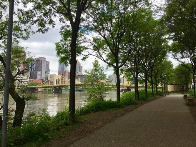
2 Trip Reports


Helpful Links
Find Hiking Trails Near Me:


")

Before you leave...
MyHikes is an indie web platform aimed to make exploring public trails easier for everyone. The site has no investors and is owned and operated by one person, Dave Miller (Founder & Admin). As the Founder, main contributor, and doer-of-all-things for MyHikes, I share my trips with over-detailed write-ups for fun on a volunteer basis and I believe that public trail information should be available to everyone.
It takes a lot of time 🕦, money 💰, and effort (including espresso shots ☕) to run MyHikes, including hiking , mapping , writing , and publishing new trails with high-quality content... along with building new features, moderating, site maintainance, and app development for iOS and Android . I simply ask that if you find MyHikes' trail guides helpful to please consider becoming a Supporter to help keep the site, iOS, and Android apps available to everyone.
Supporters unlock website and in-app perks with a one-time payment of $25 (you renew) 😎👍. Or you can simply make a Donation of your choice without a MyHikes user account. Otherwise, telling your friends about MyHikes is the next-best thing - both quick and free 🎉
Thanks for visiting MyHikes and have a great hike!️

Dave Miller
MyHikes Founder & Admin

