Nickel Run Falls and Nessmuk's Winter Camp
Distance:
5.8 Miles / 9.3 kmType:
Out-and-BackDifficulty:
HardTime to Hike:
2 hours, ~54 minutesFeatures:
Surface Type:
DirtLoading...
Loading...
The Nickel Run Falls and Nessmuk's Winter Camp hike at Tioga State Forest in Wellsboro, Pennsylvania is a difficult 5.8-mile out-and-back hike that leads two waterfalls, Nickel Run Falls and Upper Nickel Run Falls. The hike also include a trek out to a location near Nessmuk's Winter Camp along Babb Creek.
Trails
This hike follows two named trails and one unnamed trail. The first trail hikers follow is the yellow-blazed unnamed trail that crosses Babb Creek. This unnamed trail connects to the Mid State Trail (orange blazes). Eventually the Mid State Trail reaches the Nickel Run Falls Spur Trail (yellow blazes).
Note - Wet Feet
Hikers must get their feet wet or wear waders for this hike - or both.
Trail Description
This hike begins at the Village of Landrus memorial marker, where parking can also be found. The trail follows yellow blazes and immediately crosses Babb Creek. During the Spring and after heavy rains, Babb Creek can spill over into a parallel creek so you may need to cross two creek to reach the Mid State Trail.
Just after crossing Babb Creek, hikers can find some old stonework if they look downhill in between the trail and Babb Creek. This old stonework was built by the residents of Landrus, back in the late 1800's to early 1900's. Now Landrus is a non-existent ghost town.
Once you reach the Mid State Trail, take a left-hand turn to follow the orange blazes uphill. The trail will head gradually uphill for about 1-mile before flattening out. Along the way, there are massive boulders that line the trail, approximately 10-feet tall and 10 to 20-feet wide - perfect for bouldering.
Reaching Nickel Run Falls
Finally, after 1.6-miles one-way the trail will reach the Nickel Run Falls Spur Trail, with a trail sign. Hike down this yellow-blazed trail until you reach yet another trail sign. Hike 5-feet beyond the sign, take a right-hand turn, and follow the yellow blazes out to the rock ledge vista of Nickel Run Falls. The distance from the spur trail trailhead to Nickel Run Falls is no more than 0.35 miles one-way.
Hikers can enjoy Nickel Run Falls from this beautiful rock ledge lookout above the gorge before heading onward. Please be aware that the ground and rocks here can be slippery and the plunge into the gorge, in some places, is over 20-feet. Hikers will find an easy way around the rock ledge just south of the viewing point where you can hike down about 20-feet into the gorge for better views of Nickel Run Falls.
After visiting Nickel Run Falls, the hike to reach Nessmuk's Winter Camp is all downhill as it meanders parallel to Nickel Run creek before reaching Babb Creek. Eventually the trail will take a 90-degree left-hand turn once it reaches Babb Creek, where Babb Creek and Nickel Run converge. Once on this section of the trail, the hike follows the old railroad bed of the Arnot and Pine Creek (Erie) Railroad (1878 - 1952).
At Babb Creek, hike east along the flat trail. There's one fire pit along this section of trail, but it has not been used in quite a long time.
Reaching Nessmuk's Winter Camp
Not too long after hiking adjacent to Babb Creek, hikers will find
another trail sign which is labeled "Creek View", "Main Trail", "Falls"
-- each with arrows. This recording heads towards the "Creek View"
following the old railroad embankment along Babb Creek. Finally, the trail will end at the end of the old railroad embankment where it meets Babb Creek. This location has a sign marking the nearby location of Nessmuk's Winter Camp. While nothing is left of Nessmuk's camp, it's a beautiful place to find solitude like Nessmuk once did. Hikers will also find a large pool within Babb Creek just below the old railroad embankment which is home to plenty of brook trout, making this a great backcounty fishing hole. It must be noted that heavy metal runoff from mines upstream do contaminate these waters despite that trout are thriving here. There was a large and expensive effort to correct the water runoff from the old mines, which allows for fish to actually live in Babb Creek. Click here more information on the restoration of the Babb Creek watershed.
The hike back up to the Mid State Trail from here is fairly simple -- hike back to the trail sign along Babb Creek and take a right-hand turn (head uphill) along the yellow blazes to reach the Mid State Trail once again.
Reaching Upper Nickel Run Falls
After hiking back up the Nickel Run Falls Spur Trail (yellow blazes), continue hiking north along the Mid State Trail for approximately 0.5 more miles to reach the Upper Nickel Run Falls. Upper Nickel Run Falls is approximately 20-feet wide and about 8-feet tall.
From here, the hike back to parking is easy as most of it is downhill. Cross Babb Creek one more time to make your way out.
Nickel Run Falls
The main attraction of this hike is Nickel Run Falls, which is approximately 30-feet tall and 6-feet wide and lies along the yellow blazed Nickel Run Falls Spur Trail. The spur trail leads out to the waterfall with a vista above the gorge, giving hikers a view of the waterfall from about 80-feet away. Hikers can walk down around the ledge to get a better view of Nickel Run Falls. Upper Nickel Run Falls (unofficially named) can also be found about 0.5-miles up the Mid State Trail from the Nickel Run Falls trail junction.
Difficulty
This trail should be considered moderate if not hiking all the way downhill to Nessmuk's Winter Camp. While the hike back uphill is not the worst, I found it more difficult than a moderate climb.
Parking
Hikers will find parking at the "Village of Landrus" memorial marker stone. While the village of Landrus is no longer here, hikers can find some old stone walls and stone columns (that look like chimneys) in the ghost town of woods nearby (mostly directly across Babb Creek).
Pets
Dogs are allowed and must be leashed; however, please note that Babb Creek can be deep in some places, especially after heavy rainfall or during the Spring. Small dogs will not be able to make it across Babb Creek by themselves, but large dogs should have no problem.
Blaze Color
This is important - while the trail follows mostly the orange blazes of the Mid State Trail, the hike begins along yellow blazes. The Nickel Run Falls Spur Trail also follows yellow blazes. So the hike follows yellow, then orange, then yellow blazes to reach the waterfall.
Who is/was Nessmuk?
'Nessmuk' was the pen name for a George Washington
Sears (1821 - 1890). Sears was a sports writer for Forest and Stream
magazine during the 1800's. His self-guided canoe tours of the
Adirondacks became very popular - mostly based on solo, lightweight
canoe trips. Today these are known as ultralight backpacking or
portage treks. Canoeing became popular during the 1860's but canoe tours
required heavy canoes and a tour guide, so Nessmuk's tours became a hit among outdoor adventurers. Sears grew up in South Oxford
(now Webster), Massachusetts and later in life moved to Wellsboro,
Pennsylvania where he lived the rest of his life. Mount Nessmuk, just
north of Route 6 in Wellsboro Pennsylvania is named after him. For another Nessmuk hike, check out our guide on hiking Mt. Nessmuk.
Bouldering
The Mid State Trail has several large boulders that can be used for bouldering - located about 1-mile into the hike.
Warning
Bushwhacking: The Nickel Run Falls Spur Trail can be overgrown - especially when getting closer to Nessmuk's Winter Camp. Hikers should bring trail maps and an offline GPS tracking device for their safety. Additionally, there's very little to no cell phone service along this hike. Hike at your own risk.
Rattlesnakes: While rare, the Timber Rattlesnake lives in this area and tends to come down to
creeks to cool down or hunt between the end of April through the end of
September. Watch your step and give any rattlesnake you see some space.
-
Parking
41.641793, -77.207316 -
Main Trailhead
41.641861, -77.207285 -
Boulders for bouldering
41.638775, -77.218047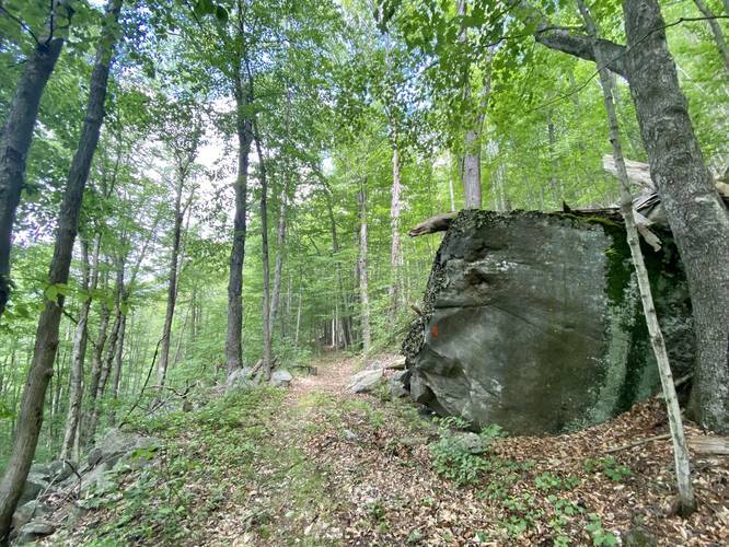
-
Boulders for bouldering
41.639008, -77.219528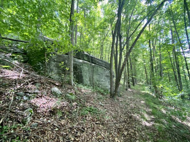
-
Nickel Run Falls
41.636833, -77.229728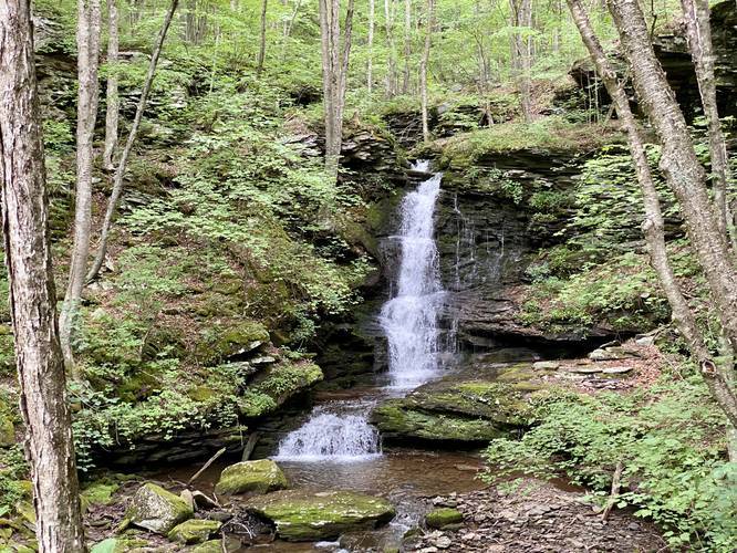
-
Campsite fire ring
41.63368, -77.22883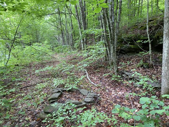
-
Trail junction along the old railroad bed
41.634373, -77.227378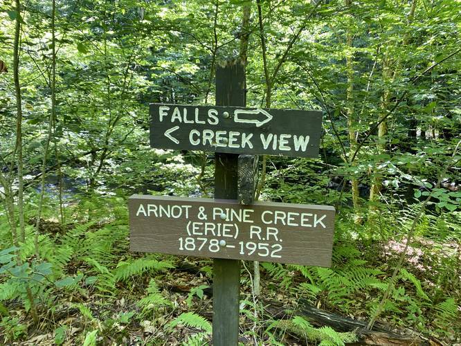
-
Near Nessmuk's Winter Camp (circa 1850s)
41.635833, -77.223953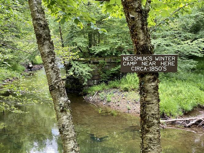
-
Upper Nickel Run Falls
41.645786, -77.226875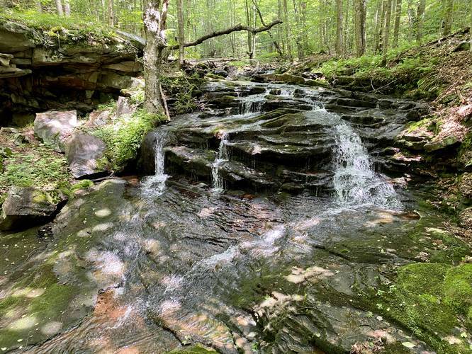
-
View Trail Map
Hiker: CoreyBHiked on: May 26, 2023Distance: 1.4 miles / 2.3 km
Hazards
Seasons
AllBlaze Color

3 Trip Reports


Helpful Links
Find Hiking Trails Near Me:


Before you leave...
MyHikes is an indie web platform aimed to make exploring public trails easier for everyone. The site has no investors and is owned and operated by one person, Dave Miller (Founder & Admin). As the Founder, main contributor, and doer-of-all-things for MyHikes, I share my trips with over-detailed write-ups for fun on a volunteer basis and I believe that public trail information should be available to everyone.
It takes a lot of time 🕦, money 💰, and effort (including espresso shots ☕) to run MyHikes, including hiking , mapping , writing , and publishing new trails with high-quality content... along with building new features, moderating, site maintainance, and app development for iOS and Android . I simply ask that if you find MyHikes' trail guides helpful to please consider becoming a Supporter to help keep the site, iOS, and Android apps available to everyone.
Supporters unlock website and in-app perks with a one-time payment of $25 (you renew) 😎👍. Or you can simply make a Donation of your choice without a MyHikes user account. Otherwise, telling your friends about MyHikes is the next-best thing - both quick and free 🎉
Thanks for visiting MyHikes and have a great hike!️

Dave Miller
MyHikes Founder & Admin

