Mt. Kearsarge Loop
Distance:
2.7 Miles / 4.3 kmType:
LoopDifficulty:
ModerateTime to Hike:
1 hour, ~21 minutesFeatures:
Surface Type:
DirtLoading...
Loading...
The Mt. Kearsarge Loop at Winslow State Park near Wilmot, New Hampshire is a moderate 2.75-mile loop hike that features panoramic mountain views from the summit of Mount Kearsarge.
Trail names: Barlow Trail, Winslow Trail
Location: 475 Kearsarge Mountain Road, Winslow State Park, Wilmot NH
Permitted uses: Hiking, Birding, Nature Study
Prohibited uses: No Trash, no fires.
Hours: The Winslow State Park has different operating hours depending on the season. Visitors should check the State's Park website (nhstateparks.org) before their visit for current hours. During our visit, the State Park was open 9:00am to 4:00pm. State Park lands are always open for recreation, but amenities, such as restrooms, may not be available when the park is closed. During winter, there is no guarantee that the area will be plowed. Those using the park after hours do so at their own risk.
Fees and Parking: Access to the parking area and trails are located inside the Winslow State Park. The parking area is huge, but hikers can call ahead to reserve a spot if they are concerned about having a spot (603-526-6168). During our visit, there was ample parking available. The fee for entrance into the park is $4.00/per person for anyone 12 years of age or older. Residents of New Hampshire over the age of 65 or children 5 years old and younger, are admitted free of charge. The fee for children aged 6 to 11 years is $2.00/per person. The park is unstaffed starting November 1st of each year and there is a self-serve pay station to deposit cash or check. Seasonal passes are available and can be viewed and purchased online at the States website: nhstateparks.org
Pets: Dogs are welcome but are supposed to be on a leash and dog waste is supposed to be carried out by the owner.
Accessibility: The trails are not wheelchair accessible.
Sanitation: There are no trash bins. Please carry out whatever you pack in. There is a small, one-person gender-neutral bathroom at the parking lot to the right of the trail entrance. There is a men's and women's bathroom on the opposite side, across from and close to, the covered picnic pavilion, however, both are currently closed. The park has three gender neutral port-a-potties in the lower parking area near the playground.
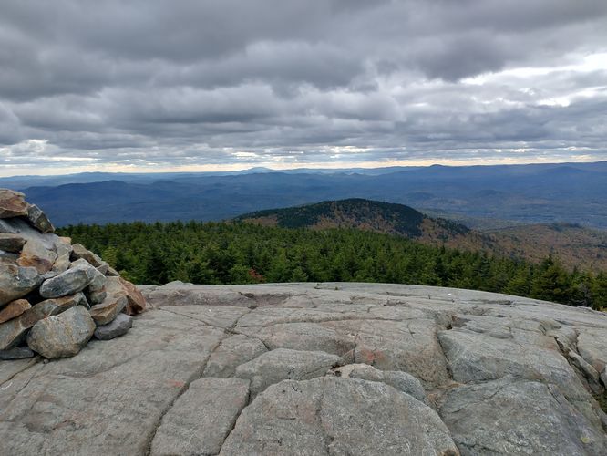
Length and Trail information: This 2.75-mile hike was done as a loop and is considered to be a moderate hike. Mount Kearsarge has and elevation of 2,937 feet and an elevation gain of over 1,200 feet. We chose to hike up the Barlow Trail and down the Winslow Trail. There is a small wooden sign at the back of the parking area that directs hikers to the trails. There is an information kiosk, but very little information is posted on it. There is no trail map posted, but there's only two options to hike, and both are very well marked, so a trail map is not a necessity. The trail blaze for the Barlow Trail is Yellow, and the blaze for the Winslow Trail is Red. Both trails are well blazed and for the most part very easy to follow. As hikers approach the summit, stone cairns will also be seen to help mark the trail. The trail is very rocky, rooted and during our hike, it was very muddy and rutted. Our advice is to take your time and watch your footing. The hike has an almost immediate and steady incline. The trail is narrow and best suited for hiking single file. This is a very popular hike, especially during Fall Foliage season, and you are very likely to encounter other hikers during your visit. Along the Barlow Trail, near the summit, hikers will be able to observe a very small, special, and very fragile ecosystem: An Alpine Bog. A sign is posted to help identify this area and visitors are reminded to observe this area from a safe distance: keeping dogs on a leash to help preserve this special spot. Once at the summit, hikers will enjoy an amazing 360-degree panorama of the surrounding area including views of the Lake Sunapee area, Mount Cardigan, Ragged Mountain, Mount Monadnock and Ascutney. It is reported that on exceptionally clear days, hikers can see the mountains of Vermont and even as far as the Atlantic Ocean and Boston. There is a fire tower atop the summit and hikers are able to climb most of the way up the tower. There are also a couple picnic tables below the tower area in case your hike includes a summit lunchbreak. A large cairn marks the summit, and the views are spectacular on this rocky mountain top.
Hazards
Seasons
AllBlaze Color
Blaze Dot
1 Trip Report
Before you leave...
MyHikes is an indie web platform aimed to make exploring public trails easier for everyone. The site has no investors and is owned and operated by one person, Dave Miller (Founder & Admin). As the Founder, main contributor, and doer-of-all-things for MyHikes, I share my trips with over-detailed write-ups for fun on a volunteer basis and I believe that public trail information should be available to everyone.
It takes a lot of time 🕦, money 💰, and effort (including espresso shots ☕) to run MyHikes, including hiking , mapping , writing , and publishing new trails with high-quality content... along with building new features, moderating, site maintainance, and app development for iOS and Android . I simply ask that if you find MyHikes' trail guides helpful to please consider becoming a Supporter to help keep the site, iOS, and Android apps available to everyone.
Supporters unlock website and in-app perks with a one-time payment of $25 (you renew) 😎👍. Or you can simply make a Donation of your choice without a MyHikes user account. Otherwise, telling your friends about MyHikes is the next-best thing - both quick and free 🎉
Thanks for visiting MyHikes and have a great hike!️
Dave Miller
MyHikes Founder & Admin


