Merkle Trail
Distance:
1.0 Mile / 1.6 kmType:
LoopDifficulty:
EasyTime to Hike:
~30 minutesFeatures:
Surface Type:
DirtLoading...
Loading...
The Merkle Trail at Usery Mountain Regional Park in Mesa, Arizona is an easy 1 mile loop hike that circles the Merkle Hills. While this trail does not have any specific view points, you'll get amazing views of the surrounding mountains, including Pass Mountain (aka "Scarface"), and the giant arrow to Phoenix mountain sign.
The trailhead can be found on both the north and south side of the Merkle Hills; however, the northern trailhead has a small spur trail that leads into the loop itself.
The trail itself is flat and unobstructed (no large rocks to trip over), so you can hike around while enjoying the scenery. This trail is also a "boundary-free" trail, so you're encouraged to leave the trail and explore around it.
Dogs are allowed on this trail.
Hazards
Seasons
All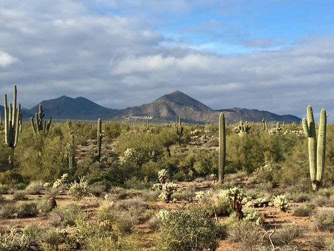
2 Trip Reports


Helpful Links
Find Hiking Trails Near Me:


Before you leave...
MyHikes is an indie web platform aimed to make exploring public trails easier for everyone. The site has no investors and is owned and operated by one person, Dave Miller (Founder & Admin). As the Founder, main contributor, and doer-of-all-things for MyHikes, I share my trips with over-detailed write-ups for fun on a volunteer basis and I believe that public trail information should be available to everyone.
It takes a lot of time 🕦, money 💰, and effort (including espresso shots ☕) to run MyHikes, including hiking , mapping , writing , and publishing new trails with high-quality content... along with building new features, moderating, site maintainance, and app development for iOS and Android . I simply ask that if you find MyHikes' trail guides helpful to please consider becoming a Supporter to help keep the site, iOS, and Android apps available to everyone.
Supporters unlock website and in-app perks with a one-time payment of $25 (you renew) 😎👍. Or you can simply make a Donation of your choice without a MyHikes user account. Otherwise, telling your friends about MyHikes is the next-best thing - both quick and free 🎉
Thanks for visiting MyHikes and have a great hike!️

Dave Miller
MyHikes Founder & Admin

