Matlock Lake
Distance:
7.3 Miles / 11.7 kmType:
Out-and-BackDifficulty:
ModerateTime to Hike:
3 hours, ~39 minutesFeatures:
Surface Type:
DirtLoading...
Loading...
Hike up the Kearsarge Pass Trail through eastern Sierra vegetation and several lakes before reaching Matlock Lake via the Matlock Lake Trail. This hike is features countless views.
The Kearsarge Pass Trail is very popular. The trail starts out in a desert environment, then gradually ascends into a sparse eastern Sierra forest. It passes several large lakes, Little Pothole Lake and Gilbert Lake, before reaching the junction with the Matlock Lake Trail.
Turn left onto the Matlock Lake Trail and immediately pass by Flower Lake before crossing over a small ridge and reaching the Matlock Lakes. The trail descends down to the lakes, with several spur trail leading around them. For the best views and campsites, take the middle trail between both lakes. Here gaze up at the jagged mountains above and the granite-rimmed lake below.
You can hike off-trail quite easily up here and explore several of the other smaller lakes in the area, such as Slim Lake with it's turquoise blue water.
Hazards
Seasons
Summer, Fall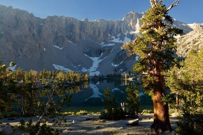
1 Trip Report


Helpful Links
Find Hiking Trails Near Me:


Before you leave...
MyHikes is an indie web platform aimed to make exploring public trails easier for everyone. The site has no investors and is owned and operated by one person, Dave Miller (Founder & Admin). As the Founder, main contributor, and doer-of-all-things for MyHikes, I share my trips with over-detailed write-ups for fun on a volunteer basis and I believe that public trail information should be available to everyone.
It takes a lot of time 🕦, money 💰, and effort (including espresso shots ☕) to run MyHikes, including hiking , mapping , writing , and publishing new trails with high-quality content... along with building new features, moderating, site maintainance, and app development for iOS and Android . I simply ask that if you find MyHikes' trail guides helpful to please consider becoming a Supporter to help keep the site, iOS, and Android apps available to everyone.
Supporters unlock website and in-app perks with a one-time payment of $25 (you renew) 😎👍. Or you can simply make a Donation of your choice without a MyHikes user account. Otherwise, telling your friends about MyHikes is the next-best thing - both quick and free 🎉
Thanks for visiting MyHikes and have a great hike!️

Dave Miller
MyHikes Founder & Admin

