Little Jax Rock Overlook
Distance:
1.3 Miles / 2.1 kmType:
Out-and-BackDifficulty:
ModerateTime to Hike:
~39 minutesFeatures:
Surface Type:
DirtLoading...
Loading...
The Little Jax Rock Overlook hike at Tioga State Forest near Wellsboro, Pennsylvania is a moderate 1.3-mile out-and-back off-trail hike that feature waterfalls along Bear Run, including a 50-foot cascade, and leads to a beautiful overlook of Pine Creek Gorge (PA Grand Canyon), Little Jax Rock Overlook.
Note: this hike is only for experienced hikers who do not mind off-trail hiking, topographic map reading, very steep hillsides, and some danger. Leave this trail for the locals and hike something like the Barbour Rock Accessible Trail instead if you just wish to find a nice and easy vista hike at the PA Grand Canyon.
Trail Description
Hikers will first start off by hiking south along the West Rim Trail for about 100-feet before veering off-trail to follow an old log slide. This old log slide also leads out to the Bear Run Falls waterfall; however, you can easily miss the first 2 smaller waterfalls along Bear Run if you continue along the log slide. Hikers should also note that the log slide is not maintained, it is not an official trail, and has overgrown hemlocks and rhododendron blocking the trail in several sections -- just push through the overgrowth to continue onward.
Bear Run Falls Major / Step Falls & Little Step Falls
After passing the small downward slope to the Bear Run Falls, off-trail about 0.44 miles into the hike, hikers will continue heading downstream along Bear Run creek. Eventually the trail will take a sharp 20-foot drop as it runs downhill alongside the 35-40 foot tall waterfall, Bear Run Falls Major. I named this waterfall Bear Run Falls Major as the upper waterfalls are much smaller. At Bear Run Falls Major / Step Falls (35-40-foot waterfall), the hillside slopes steeply toward Bear Run creek. I've also named this waterfall Step Falls because when the water is dried up, the shale bedrock underneath looks like steps. To reach the base of Step Falls, hikers must scramble a sketchy hillside - for experienced gorge hikers only. Just below Step Falls is Little Step Falls, which cascades down its own series of shale steps at just 7-feet tall. I'd recommend staying out of this section of the creek during high-water seasons.
Reaching Little Jax Rock - Mile 0.45 - Mile 0.63
After visiting Step Falls, hikers must follow the flattest route, leading slightly uphill, to continue following the creek downstream. The ground will feel a bit sketchy for about 100-feet while you climb up and out from Bear Run Falls Major along these steep slopes. After that small climb out, the ground will widen as you make your way out toward Little Jax Rock and the overlook. Around mile 0.6, roughly 300-feet from the overlook, hikers will reach yet another steep section of terrain where the trail meets up with a cliff's edge. Hikers will want to head uphill here for about 50-feet to continue hiking along the flatter terrain. Just after this cliff area, about 250-feet further, lies Little Jax Rock and the overlook.
Little Jax Rock Overlook
Hikers will finally reach the overlook, Little Jax Rock Overlook (named after my dog, Jax), around mile 0.75. There is not much room to sit and enjoy the vista due to the slanted terrain of the hill, but there's plenty of room to enjoy the view. Watch your step as there is nothing in the way from falling the 100+ feet down into Pine Creek Gorge below from the cliffs of Little Jax Rock.
Hiking back from the vista to the parking area is just as easy as it is hiking in, which can be just as confusing. It can be easy to hike uphill and away from Bear Run creek. If that's the case, you may end up bushwhacking your way to the West Rim Trail which is also easy to follow. However, the general rule of thumb when hiking back along this route is to look for the shuffled leaves and dirt that you or deer made when heading in.
Parking
Hikers will find parking at the coordinates provided where the West Rim Trail crosses Colton Point Road, just outside of the Colton Point State Park boundaries. The parking lot is large enough for no more than 3 vehicles.
Pets
Dogs are allowed if leashed; however, this off-trail hike can be very sketchy at times. Keep your dog on leash at all times to ensure they do not fall down any ravine or cliff.
Dangers
This hike is full of dangers, so hikers must be aware before attempting this hike. First, this hike does not follow any defined trail. For the most part it follows what appears to be an old log slide from 100-years ago when this area was logged out. Parts of the hike follow deer paths or no defined path at all. Hikers must be comfortable reading and navigating a topographic map with or without a GPS device. Hikers should consider bringing a GPS device and downloading this GPX track to ensure you go to the correct places. Snakes are also a danger on this trail - the Timber Rattlesnake can be living in these rocky outcroppings and ledges that sit along the steep sections of trail. Last, the trail passes several very very steep hillsides, ravines, and cliffs. It's best you bring trekking poles, the proper footwear, and to hike slow to ensure you do not trip and fall. There is no cell phone service and the closest people out near this place are along the West Rim Trail. If you get hurt, you may not be heard. Hike at your own risk.
Difficulty
This hike is rated as 'moderate' because of the sketchy off-trail hiking, steep hillsides, and topo navigation. The elevation change and elevation gain may make you sweat, but it's minimal in the long run.
-
Parking
41.716986, -77.46353 -
Main Trailhead
41.716937, -77.463464 -
Little Jax Rock Overlook
41.71027, -77.461548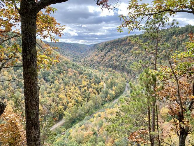
-
Old-growth hemlock grove
41.713981, -77.464408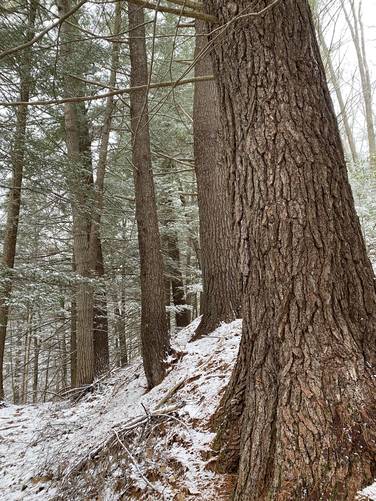
-
Bear Run waterfall approx. 10-feet tall
41.713336, -77.464669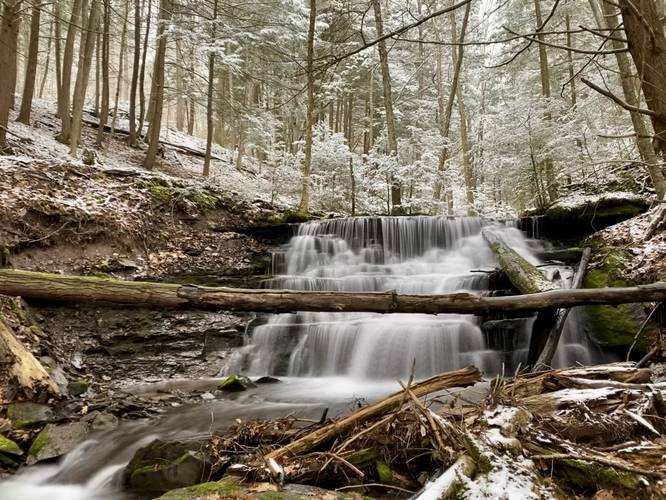
-
Bear Run waterfall two-tier cascade. 10-feet above, 4-feet below
41.713108, -77.464753
-
Seasonal waterfall
41.712906, -77.464767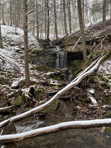
-
Step Falls (Bear Run Falls Major), approx. 35-feet tall
41.711714, -77.463881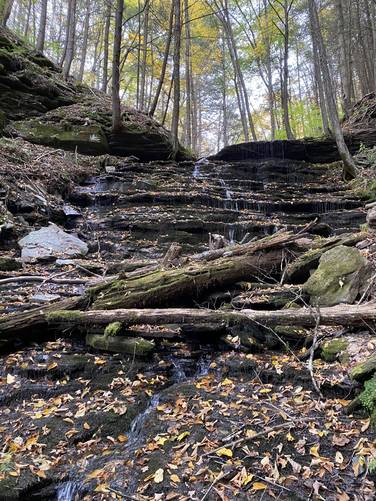
-
Little Step Falls. approx. 7-feet tall
41.711523, -77.463785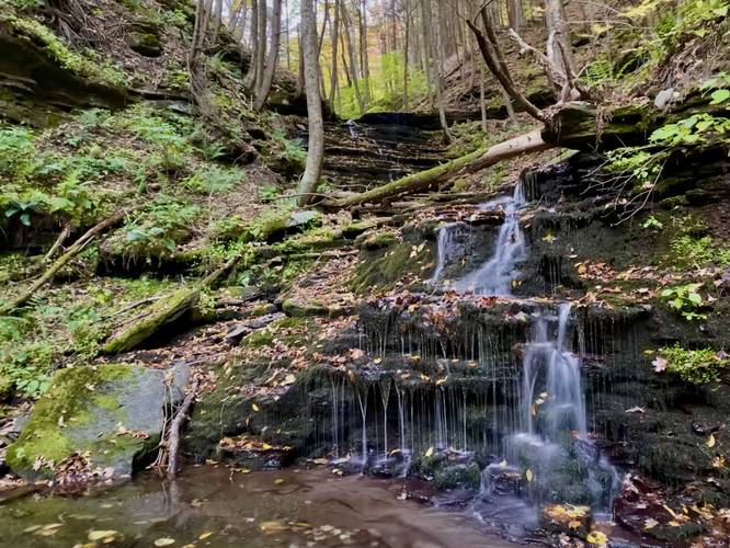
-
Slab Falls approx. 7-feet tall
41.712642, -77.464706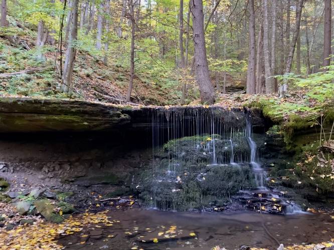
-
View of Step Falls from the steep hillside
41.711731, -77.463673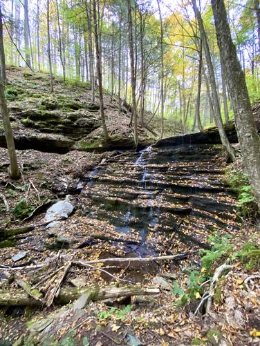
-
View Trail Map
Hiker: Shawng13Hiked on: November 23, 2023Distance: 1.8 miles / 2.9 km
Hazards
Seasons
All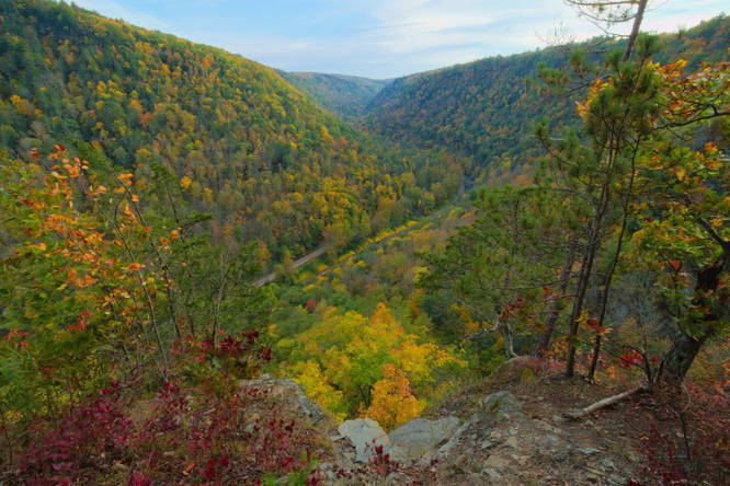


7 Trip Reports


Helpful Links
Find Hiking Trails Near Me:


Before you leave...
MyHikes is an indie web platform aimed to make exploring public trails easier for everyone. The site has no investors and is owned and operated by one person, Dave Miller (Founder & Admin). As the Founder, main contributor, and doer-of-all-things for MyHikes, I share my trips with over-detailed write-ups for fun on a volunteer basis and I believe that public trail information should be available to everyone.
It takes a lot of time 🕦, money 💰, and effort (including espresso shots ☕) to run MyHikes, including hiking , mapping , writing , and publishing new trails with high-quality content... along with building new features, moderating, site maintainance, and app development for iOS and Android . I simply ask that if you find MyHikes' trail guides helpful to please consider becoming a Supporter to help keep the site, iOS, and Android apps available to everyone.
Supporters unlock website and in-app perks with a one-time payment of $25 (you renew) 😎👍. Or you can simply make a Donation of your choice without a MyHikes user account. Otherwise, telling your friends about MyHikes is the next-best thing - both quick and free 🎉
Thanks for visiting MyHikes and have a great hike!️

Dave Miller
MyHikes Founder & Admin

