Little Chebeague Island Hike
Distance:
7.4 Miles / 11.9 kmType:
Out-and-BackDifficulty:
ModerateTime to Hike:
3 hours, ~42 minutesFeatures:
Surface Type:
DirtLoading...
Loading...
The Little Chebeague Island Hike on Chebeague Island in Maine is a moderate 7.4-mile out-and-back hike that leads out to Little Chebeague Island and features beautiful views of the islands outside of Portland.
This trail is a bit different from the summit hikes I normally post, but it's a great adventure so I thought it deserved some attention.
Little Chebeague Island is a small island off the coast of Great Chebeague Island. You can get there by taking the ferry from Portland and getting off at Great Chebeague, then at low tide only, you can walk across the sand bar and get to Little Chebeague. There are trails throughout the island, along with a small number of campsites that are free to stay at. This track shows the route from the ferry dock, across the sand bar and onto the island, and includes some of the trails on Little Chebeague.
The most important thing about this hike is getting your timing right. Choosing the right ferry to get you to the sandbar at low tide (you have about a 2, maybe 3 hour window surrounding low tide to cross before you're stuck for another 12 hours).
Pets: Dogs are allowed if leashed and their waste must be carried out by the hiker.
Camping: There are a small number of campsites that are free to stay at. If you're camping you need to bring all the water you'll need, because there's none on the island.
Water Sources: You need to bring all the water you'll need, because there's none on the island, whether you're camping or not.
Hazards
Seasons
All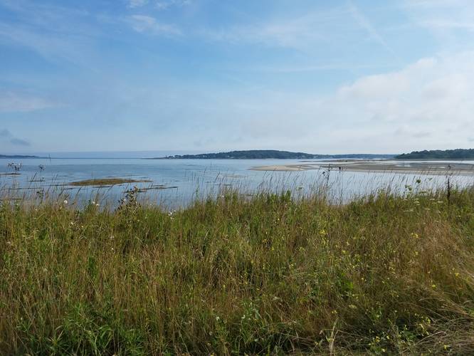
1 Trip Report


Helpful Links
Find Hiking Trails Near Me:


Before you leave...
MyHikes is an indie web platform aimed to make exploring public trails easier for everyone. The site has no investors and is owned and operated by one person, Dave Miller (Founder & Admin). As the Founder, main contributor, and doer-of-all-things for MyHikes, I share my trips with over-detailed write-ups for fun on a volunteer basis and I believe that public trail information should be available to everyone.
It takes a lot of time 🕦, money 💰, and effort (including espresso shots ☕) to run MyHikes, including hiking , mapping , writing , and publishing new trails with high-quality content... along with building new features, moderating, site maintainance, and app development for iOS and Android . I simply ask that if you find MyHikes' trail guides helpful to please consider becoming a Supporter to help keep the site, iOS, and Android apps available to everyone.
Supporters unlock website and in-app perks with a one-time payment of $25 (you renew) 😎👍. Or you can simply make a Donation of your choice without a MyHikes user account. Otherwise, telling your friends about MyHikes is the next-best thing - both quick and free 🎉
Thanks for visiting MyHikes and have a great hike!️

Dave Miller
MyHikes Founder & Admin

