John Dee Trail
Distance:
0.1 Miles / 0.2 kmType:
One-WayDifficulty:
EasyTime to Hike:
~5 minutesFeatures:
Surface Type:
PavedLoading...
Loading...
The John Dee Trail at Florence Keller Regional Park in Crescent City, California is an easy 0.1-mile one-way trail that cuts through an ancient Redwood Grove and connects to other trails in the park.
This trail is short, paved, and mostly flat which makes it a very easy hike for all ages.
Parking: Parking can be found in various lots or at a reserved campsite at the park.
Camping: Camping is allowed at Florence Keller Regional Park - the park has a couple dozen campsites for $15/night. Visitors are allowed to camp at the park for up to 5 nights per year per the park's reguations. The park also has 14 RV campsites for $20/night.
Facilities: There's one small restroom available at the park. If you're planning on camping, there are no showers available.
Pets: Dogs are allowed is leashed and their waste must be carried out by the hiker.
Biking: Biking is permitted, but be careful of the hikers along the short trails in the park.
Hazards
Seasons
All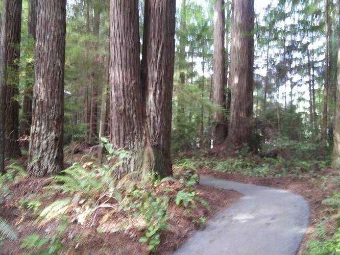
1 Trip Report


Helpful Links
Find Hiking Trails Near Me:


Before you leave...
MyHikes is an indie web platform aimed to make exploring public trails easier for everyone. The site has no investors and is owned and operated by one person, Dave Miller (Founder & Admin). As the Founder, main contributor, and doer-of-all-things for MyHikes, I share my trips with over-detailed write-ups for fun on a volunteer basis and I believe that public trail information should be available to everyone.
It takes a lot of time 🕦, money 💰, and effort (including espresso shots ☕) to run MyHikes, including hiking , mapping , writing , and publishing new trails with high-quality content... along with building new features, moderating, site maintainance, and app development for iOS and Android . I simply ask that if you find MyHikes' trail guides helpful to please consider becoming a Supporter to help keep the site, iOS, and Android apps available to everyone.
Supporters unlock website and in-app perks with a one-time payment of $25 (you renew) 😎👍. Or you can simply make a Donation of your choice without a MyHikes user account. Otherwise, telling your friends about MyHikes is the next-best thing - both quick and free 🎉
Thanks for visiting MyHikes and have a great hike!️

Dave Miller
MyHikes Founder & Admin

