Jamison Run Vista
Distance:
0 Miles / 0 kmType:
Out-and-BackDifficulty:
EasyTime to Hike:
~5 minutesFeatures:
Surface Type:
DirtLoading...
Loading...
Jamison Run Vista at Susquehannock State Forest near Austin, Pennsylvania is an accessible roadside southwest-facing view of the mountains surrounding Jamison Run.
This
is not a hike, but rather a few steps out of
your car to take in the views of the mountains at the Jamison Run Vista. This
is a great spot for folks to enjoy the mountains of the PA Wilds
without having to do any hiking or really any walking if they choose
not to or physically can't. If you choose to walk, the distance is
negligible, but there are different vantage points from each end of the
parking turnout.
Parking
Visitors will find parking at the coordinates provided. The turnout is large enough to fit a few vehicles at most.
Pets
Dogs are allowed if leashed and cleaned up after.
No Winter Maintenance
There's
no Winter maintenance on these forest roads, so don't expect to be able
to reach this vista unless on a snowmobile (if permitted) or a very long hike.
-
Parking
41.597062, -77.859343 -
Main Trailhead
41.597093, -77.859355 -
Jamison Run Vista
41.597083, -77.859375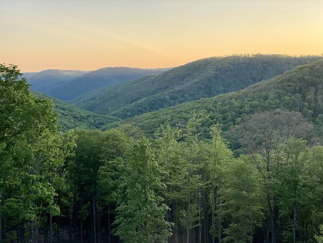
Hazards
Seasons
Spring, Summer, Fall
1 Trip Report


Before you leave...
MyHikes is an indie web platform aimed to make exploring public trails easier for everyone. The site has no investors and is owned and operated by one person, Dave Miller (Founder & Admin). As the Founder, main contributor, and doer-of-all-things for MyHikes, I share my trips with over-detailed write-ups for fun on a volunteer basis and I believe that public trail information should be available to everyone.
It takes a lot of time 🕦, money 💰, and effort (including espresso shots ☕) to run MyHikes, including hiking , mapping , writing , and publishing new trails with high-quality content... along with building new features, moderating, site maintainance, and app development for iOS and Android . I simply ask that if you find MyHikes' trail guides helpful to please consider becoming a Supporter to help keep the site, iOS, and Android apps available to everyone.
Supporters unlock website and in-app perks with a one-time payment of $25 (you renew) 😎👍. Or you can simply make a Donation of your choice without a MyHikes user account. Otherwise, telling your friends about MyHikes is the next-best thing - both quick and free 🎉
Thanks for visiting MyHikes and have a great hike!️

Dave Miller
MyHikes Founder & Admin

