Historic Cherry Springs Tavern
Distance:
0.3 Miles / 0.5 kmType:
Out-and-BackDifficulty:
EasyTime to Hike:
~9 minutesFeatures:
Surface Type:
Dirt
In today's world, the Cherry Spring State Park is a busy place with lots of recreational opportunities including public Stargazing Programs, a Woodsman's Show, and an overnight Astronomy Observation field. This area has become a haven for astrometry, and is on State Route 44 at Cherry Springs State Park in Potter County, Pennsylvania.
Among the array of the modern park amenities, sits a rather odd, older-looking structure. This Historic Cherry Springs Tavern, at the Cherry Springs State Park, is a replica of the long gone original and was built by the CCC in the 1930's (or maybe it was built by German POWs during WWII in the 1940's). Anyway it got built, and it is in the process of being saved and restored versus being torn down, as it's current condition is in need of repair. Let's hope that a plan is carried forward, as we certainly want to encourage the historic preservation of this CCC-era hand-crafted building.
In a much earlier time, the glow of a candle from the original Cherry Springs Tavern beckoned the lonely traveler to this place of shelter in the seemly-boundless wilderness of that time. History tells us that in 1818, Jonathan Edgecomb constructed the original log house along the Jersey Shore Pike in dark sky wilderness that was once Potter County. This byway is now known as the Highway to the Stars, and Cherry Springs State park is Potter County's most visited attraction.
Trails
This structure is located just off of the State Route 44, and can be seen from the public roadway.
Maintained pathways lead to the picnic area that is about 500 feet from the Cherry Springs State Park visitors parking near the Night Sky Public Viewing. By way of these pathways, the visitor can complete a short loop by walking to find the picnic area and then continuing on toward the Historic Cherry Springs Tavern, which is accessible by crossing the grassy lawn along State Route 44, and is about another 500 feet beyond the picnic area.
The picnic area has picnic tables and charcoal grills located on the open hill-side just before reaching the location of the Historic Cherry Springs Tavern. There's an Information Kiosk and restroom facilities near the visitors parking area. An information display about the original Cherry Springs Tavern in located in the grassy area beyond the picnic area, and just across the rustic campground access road on the way to the Historic Cherry Springs Tavern.
Hike Description
No real hiking is required to visit this Historic Cherry Springs Tavern. Visitors must walk less than one-quarter mile to get to the Historic Cherry Springs Tavern from the visitors parking area. The walking surface starts as a gravel pathway and then becomes a grassy lawn, and is mostly flat
Parking
Hikers will find a very large visitors parking area near by the coordinates provided.
Pets
Park policy allows Pets on the grounds except for the Astronomy Observation Area and the campground.
Biking
Biking is allowed along all of these multi-use trails and roads in the area except for the STS. Additionally, horses are not allowed along the STS.
Camping and Backpacking
Although camping is allowed along trails in the Susquehannock State Forest, PA where state forest rules permit backcountry / dispersed / primitive camping. This structure just off of State Route 44, and is not suitable Backpacking. The Susquehannock Trail System aka STS is by far the best place to backpack in this area; but it would be best for the camper to park at another pre-defined parking area for any extended hikes or overnight camping trips.
Hikers can find overnight parking for extended hiking trips at the Bureau of Forestry headquarters on US Route 6 on top of Denton Hill. The lot is large enough to hold dozens of vehicles with some amenities including maps and informational kiosks, and restrooms, and serves as the "Northern Gateway" which provides access to the northern portion of the STS loop.. See Duck Ponds Short Loop for extended trip parking coordinates and details to find the route to the STS.
Cherry Spring State Park offers rustic campsites within the park on a first come, first serve bases, and reservations are needed and can be made at www.visitPAparks.com.
History and Historical Points of Interest
Dense forests of magnificent white pine, hemlock and hardwoods grew here in Potter County for many decades. In the late 1800's and early 1900's, industrial saw mills, tanneries, and chemical plants were established, using wood or bark as raw materials which brought rapid population increases. As the hillsides became barren, the population spiraled downward with much of the deforested timberland abandoned. Before than, Native Americans had passed through the forested wilderness on hunting expeditions.
The Historic Cherry Springs Tavern is a replica of the original and was constructed during the Great Depression by the Civilian Conservation Corps.
Jonathan Edgecomb, an early settler in Potter County, constructed the original log house in 1818.
-
Parking
41.664049, -77.822938 -
Main Trailhead
41.664049, -77.822938 -
Information Display about Original Tavern
41.66314, -77.822865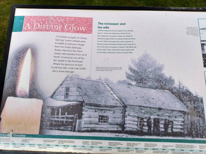
-
Replica of Original Tavern
41.662876, -77.822737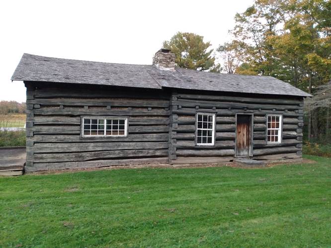
Hazards
Seasons
AllLoading...
Loading...

1 Trip Report


Before you leave...
MyHikes is an indie web platform aimed to make exploring public trails easier for everyone. The site has no investors and is owned and operated by one person, Dave Miller (Founder & Admin). As the Founder, main contributor, and doer-of-all-things for MyHikes, I share my trips with over-detailed write-ups for fun on a volunteer basis and I believe that public trail information should be available to everyone.
It takes a lot of time 🕦, money 💰, and effort (including espresso shots ☕) to run MyHikes, including hiking , mapping , writing , and publishing new trails with high-quality content... along with building new features, moderating, site maintainance, and app development for iOS and Android . I simply ask that if you find MyHikes' trail guides helpful to please consider becoming a Supporter to help keep the site, iOS, and Android apps available to everyone.
Supporters unlock website and in-app perks with a one-time payment of $25 (you renew) 😎👍. Or you can simply make a Donation of your choice without a MyHikes user account. Otherwise, telling your friends about MyHikes is the next-best thing - both quick and free 🎉
Thanks for visiting MyHikes and have a great hike!️

Dave Miller
MyHikes Founder & Admin

