Hidden Valley Natural Tunnel Hike
Distance:
3.4 Miles / 5.5 kmType:
Out-and-BackDifficulty:
HardTime to Hike:
1 hour, ~42 minutesFeatures:
Surface Type:
DirtLoading...
Loading...
The Hidden Valley Natural Tunnel Hike at South Mountain Park in Phoenix, Arizona is a very popular and difficult 3.4 mile out-and-back hike to a natural rock tunnel formation along with views of downtown Phoenix, Camelback Mountain, and Piestewa Peak. This hike technically follows three trails - Mormon Trail, South Mountain National Trail, and the Hidden Valley Trail.
The hike starts off along the Mormon Trail and quickly ascends South Mountain for the next 1.2 miles. After 1.2 miles, you'll reach a trail junction with the Mormon Trail and the Mormon Loop Trail - stay right at this intersection. You can also take a quick detour (shown in this GPS recording) up the Mormon Loop Trail for 0.1 miles one-way to the top of a hill with spectacular views of downtown Phoenix, Camelback Mountain, and Piestewa Peak.
Continuing on from the first trail junction, you'll hike for an additional 0.2 miles before reaching yet another trail junction with the South Mountain National Trail - take a left-hand turn here. Follow the National Trail for about 0.1 miles until you reach another trail junction - stay right at this trail junction to follow the Hidden Valley Trail.
After reaching the Hidden Valley Trail, you'll reach the Natural Tunnel in just under 0.1 miles. This GPS recording ends just after the Natural Tunnel.
Note: After the Natural Tunnel, the trail hits a small rock cliff - about 10 feet tall or less; however, there's no defined path up to the top of the rock. The trail does continue on to Fat Man's Pass from here, but you'll need to scale the short rock cliff to continue your hike. This recording ends at the back of the Natural Tunnel.
Natural Tunnel: The natural tunnel is a canyon where massive boulders fell into it, creating a tunnel you can hike through.
Lookout Points: There are various views along this trail and you'll get plenty of views of Phoenix and the surrounding area not very far up the trail. If you just want a view without too much hiking, you don't need to go far up the Mormon Trail to get it. Otherwise, check out the top of the hill by taking a left at the first trail junction heading up South Mountain, it's worth a stop.
Biking is allowed but not recommended due to the large number of hikers on this trail.
-
Parking
33.366473, -112.030529 -
Main Trailhead
33.366342, -112.031012 -
Natural Tunnel
33.354217, -112.018203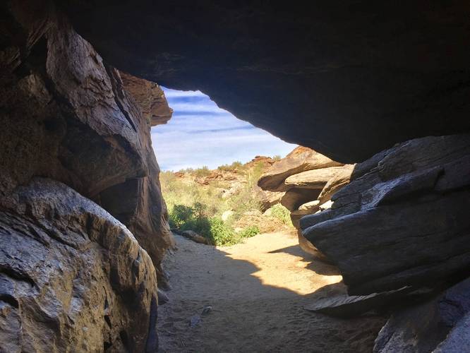
-
View of downtown Phoenix
33.357967, -112.021142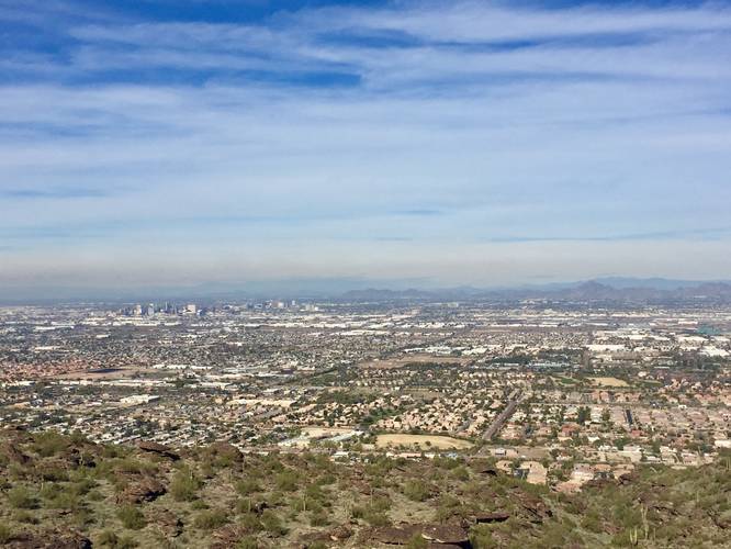
Hazards
Seasons
All
1 Trip Report


Helpful Links
Find Hiking Trails Near Me:


Before you leave...
MyHikes is an indie web platform aimed to make exploring public trails easier for everyone. The site has no investors and is owned and operated by one person, Dave Miller (Founder & Admin). As the Founder, main contributor, and doer-of-all-things for MyHikes, I share my trips with over-detailed write-ups for fun on a volunteer basis and I believe that public trail information should be available to everyone.
It takes a lot of time 🕦, money 💰, and effort (including espresso shots ☕) to run MyHikes, including hiking , mapping , writing , and publishing new trails with high-quality content... along with building new features, moderating, site maintainance, and app development for iOS and Android . I simply ask that if you find MyHikes' trail guides helpful to please consider becoming a Supporter to help keep the site, iOS, and Android apps available to everyone.
Supporters unlock website and in-app perks with a one-time payment of $25 (you renew) 😎👍. Or you can simply make a Donation of your choice without a MyHikes user account. Otherwise, telling your friends about MyHikes is the next-best thing - both quick and free 🎉
Thanks for visiting MyHikes and have a great hike!️

Dave Miller
MyHikes Founder & Admin

