Hadley Reservoir
Distance:
0.3 Miles / 0.5 kmType:
LoopDifficulty:
EasyTime to Hike:
~9 minutesFeatures:
Surface Type:
DirtLoading...
Loading...
The Hadley Reservoir in Hadley, Massachusetts is a short 0.3 mile loop hike to the reservoir and back to parking.
The Hadley Reservoir (aka the Bay Road Reservoir) is a popular spot to cool down during the Summer and you can often find a decent amount of cars parked in the lot on hot days. The trail leads in about 0.1 miles before reaching a small trail on the right that leads down to the reservoir. If you skip the first trail on your right, you can take the 2nd trail on your right, which leads to the same place. This recording heads in and takes the 2nd right-hand turn, follows the reservoir to the north shore, and then heads out along the trail at the 1st right-hand turn from the main trail.
This area has a ton of unnamed and unblazed trails that run through the woods here, so this is just one small section. Hunting seems to be allowed in these woods as well, so wear orange during hunting season.
Map: Please note that the default ESRI topographic map tiles do not display the reservoir for some reason. Use the map toggle below the map to view the Google Maps tiles to see where the trail lies next to the reservoir.
Parking: Please note that only permit parking is allowed at the parking lot here. If you're a Hadley resident, you can read about how to get a permit here. If you do not have a permit, you're parking at your own risk of getting towed at your own expense. If you're concerned about being towed, you can park at Hampshire College across the street and walk over to the trailhead, since Hampshire College likely won't tow your vehicle.
Hazards
Seasons
All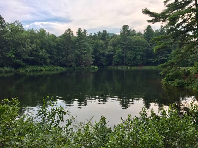
2 Trip Reports


Helpful Links
Find Hiking Trails Near Me:


Before you leave...
MyHikes is an indie web platform aimed to make exploring public trails easier for everyone. The site has no investors and is owned and operated by one person, Dave Miller (Founder & Admin). As the Founder, main contributor, and doer-of-all-things for MyHikes, I share my trips with over-detailed write-ups for fun on a volunteer basis and I believe that public trail information should be available to everyone.
It takes a lot of time 🕦, money 💰, and effort (including espresso shots ☕) to run MyHikes, including hiking , mapping , writing , and publishing new trails with high-quality content... along with building new features, moderating, site maintainance, and app development for iOS and Android . I simply ask that if you find MyHikes' trail guides helpful to please consider becoming a Supporter to help keep the site, iOS, and Android apps available to everyone.
Supporters unlock website and in-app perks with a one-time payment of $25 (you renew) 😎👍. Or you can simply make a Donation of your choice without a MyHikes user account. Otherwise, telling your friends about MyHikes is the next-best thing - both quick and free 🎉
Thanks for visiting MyHikes and have a great hike!️

Dave Miller
MyHikes Founder & Admin

