Thundermountain Equestrian Trail
Distance:
1.2 Miles / 1.9 kmType:
Out-and-BackDifficulty:
ModerateTime to Hike:
~36 minutesFeatures:
Surface Type:
DirtLoading...
Loading...
Thundermountain Equestrian Trail at Elk State Forest near Dents Run, Pennsylvania is a moderate backpacking trail that leads into the wilderness of Elk State Forest. The trail itself is much longer than the reported 1.2 mile out-and-back distance here, but we only hiked a small portion of this trail before setting up camp to test out some new gear. The trail is lightly-trafficked and is not very popular, but you may see other backpackers or horseback riders along the trail from time to time, especially during warmer months.
Wild elk are present in these woods and we did hear a male elk bugling at night near out campsite. Unfortunately we did not venture far enough to find any views or lookout points, but this is a great backpacking trail for north-central Pennsylvania.
Parking
Parking is located near the coordinates provided, just down the street from the trailhead.
Pets
Dogs are allowed if leashed and their waste should be carried out by the hiker.
Camping and Backpacking
Backpacking is allowed on this trail. Please follow all Elk State Forest rules and regulations when dispersed / primitive / backcountry camping.
-
Parking
41.401661, -78.295551 -
Main Trailhead
41.401233, -78.298454 -
Setting up the campsite
41.39793, -78.298295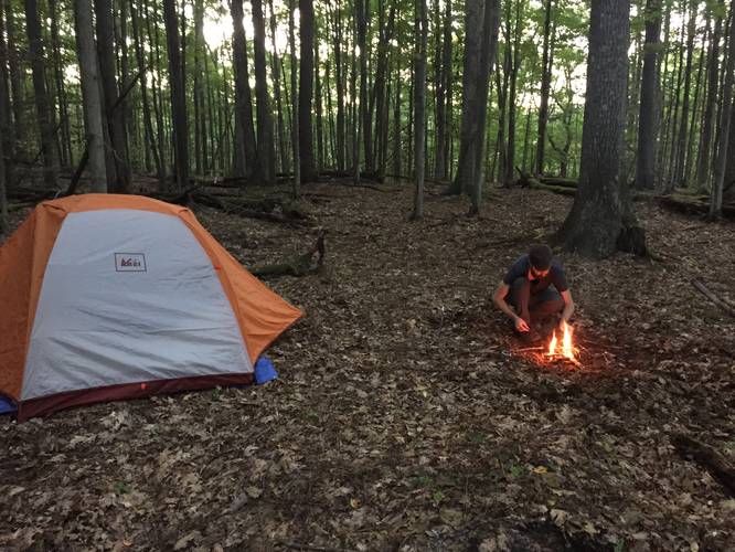
Hazards
Season
Summer
2 Trip Reports


Helpful Links
Find Hiking Trails Near Me:


Before you leave...
MyHikes is an indie web platform aimed to make exploring public trails easier for everyone. The site has no investors and is owned and operated by one person, Dave Miller (Founder & Admin). As the Founder, main contributor, and doer-of-all-things for MyHikes, I share my trips with over-detailed write-ups for fun on a volunteer basis and I believe that public trail information should be available to everyone.
It takes a lot of time 🕦, money 💰, and effort (including espresso shots ☕) to run MyHikes, including hiking , mapping , writing , and publishing new trails with high-quality content... along with building new features, moderating, site maintainance, and app development for iOS and Android . I simply ask that if you find MyHikes' trail guides helpful to please consider becoming a Supporter to help keep the site, iOS, and Android apps available to everyone.
Supporters unlock website and in-app perks with a one-time payment of $25 (you renew) 😎👍. Or you can simply make a Donation of your choice without a MyHikes user account. Otherwise, telling your friends about MyHikes is the next-best thing - both quick and free 🎉
Thanks for visiting MyHikes and have a great hike!️

Dave Miller
MyHikes Founder & Admin

