Eliot Glacier Moraine Loop
Distance:
2.7 Miles / 4.3 kmType:
LoopDifficulty:
ModerateTime to Hike:
1 hour, ~21 minutesFeatures:
Surface Type:
DirtLoading...
Loading...
The Eliot Glacier Moraine Loop at Mount Hood National Forest in Mount Hood, Oregon is a moderate 2.7-mile loop hike that features stunning views of Mount Hood along with a hike up to Eliot Glacier.
This loop hike provides some of the best views anywhere on Mount Hood of its glaciers and moraines. The Eliot Glacier is the largest glacier on Mt. Hood, and also the most impressive. It cascades down from the summit in a jumbled mass of crevasses, before snaking its way down between two moraines and feeding the raging Eliot Branch.
Starting from the Cloud Cap Trailhead, take the Trail 600 Spur a very short ways through a walk in campground to meet up with the Timberline Trail. Take the Timberline Trail #600 toward Cooper Spur Shelter. Do not take a left on the Timberline Trail, and do not take a right onto the Tilly Jane Trailhead.
At the next junction, also a very short ways ahead, take a right onto the Eliot East Moraine Trail #600X, signed "Eliot East Moraine."
Follow this trail as it makes its way up through sparse, sandy, and rocky pine forest before climbing up to the top of the lower end of the Eliot Glacier Moraine. From here, the trail traverses across the very top of the moraine ridge. Always stay to the top of the moraine, avoiding any side trails down either side.
Down below, the Eliot Branch gushes out from beneath the lower snout of Eliot Glacier. Notice the difference of color of the glacier: the lower half is covered in rock and debris, while the upper part is white. This is because the lower half is melting faster than winter snowfall can replace it due to climate change, and the upper part the snowfall is able to keep up with the rate of melting (Tom Kloster).
At the end of the moraine walk, you will reach a large rock cairn, marking the end of the official trail. Beyond, the trail is for climbers only and potentially dangerous for the average hiker. You can walk a bit further to catch a trail making its way down the left side of the moraine.
The trail then follows below the moraine in a small depression, before turning to the right (south) to lead to the Cooper Spur Shelter.
At Cooper Spur Shelter, take any informal path down to meet up with the Timberline Trail, and follow it down. It starts out in tundra, then transitions into sandy switchbacks, then enters the forest.
At the junction with the Tilly Jane Trailhead, stick to the Timberline Trail to your left.
At the Eliot East Moraine Trail junction, stick to the Timberline Trail #600, on your right.
From here, follow the same way you came up. Timberline Trail down to the Timberline Spur Trail through the walk in campground, then back to the Cloud Cap Trailhead. Never make the mistake to take the Tilly Jane Trailhead on this loop. On this loop, you will never cross the Eliot Branch Creek, nor will you descend the steeper side of the moraine down to the Eliot Branch.
Road to Cloud Cap Trailhead:
The road to the trailhead is a car accessible gravel road, but there are several waterbars to slow down for. There are may also be a few potholes–there were down at the beginning on my trip here. The last stretch of road is also narrow and very rocky.
Pets: Dogs are allowed if leashed and their waste must be carried out by the hiker.
Hazards
Seasons
Summer, Fall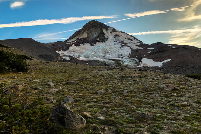
1 Trip Report


Helpful Links
Find Hiking Trails Near Me:


Before you leave...
MyHikes is an indie web platform aimed to make exploring public trails easier for everyone. The site has no investors and is owned and operated by one person, Dave Miller (Founder & Admin). As the Founder, main contributor, and doer-of-all-things for MyHikes, I share my trips with over-detailed write-ups for fun on a volunteer basis and I believe that public trail information should be available to everyone.
It takes a lot of time 🕦, money 💰, and effort (including espresso shots ☕) to run MyHikes, including hiking , mapping , writing , and publishing new trails with high-quality content... along with building new features, moderating, site maintainance, and app development for iOS and Android . I simply ask that if you find MyHikes' trail guides helpful to please consider becoming a Supporter to help keep the site, iOS, and Android apps available to everyone.
Supporters unlock website and in-app perks with a one-time payment of $25 (you renew) 😎👍. Or you can simply make a Donation of your choice without a MyHikes user account. Otherwise, telling your friends about MyHikes is the next-best thing - both quick and free 🎉
Thanks for visiting MyHikes and have a great hike!️

Dave Miller
MyHikes Founder & Admin

