County Line View Trail
Distance:
0.3 Miles / 0.5 kmType:
Out-and-BackDifficulty:
EasyTime to Hike:
~9 minutesFeatures:
Surface Type:
DirtLoading...
Loading...
The County Line View Trail at Sproul State Forest in Westport, Pennsylvania is an easy 0.3-mile out-and-back hike with an amazing view and campsite at the end of the trail.
This trail is a great spot for car camping and creating a basecamp to hike within the Jerry Ridge section of Sproul State Forest.
The trail itself is very short and flat, with a few areas to setup tents and hammocks. At the end of the trail is a nice campsite with a great view of the Sinnemahoning Creek and the mountains surrounding this section of Sproul State Forest.
Road Conditions: Jerry Ridge Rd and the roads leading to it are
all dirt. These roads can often be extremely muddy during the rainy
seasons and if you're not careful, your car could get stuck. There's also no cell service for dozens of miles.
If you plan to drive in, it's often an 11-mile one-way drive to get to
the trailhead, so come prepared with a vehicle that can handle these
conditions.
Hazards
Seasons
All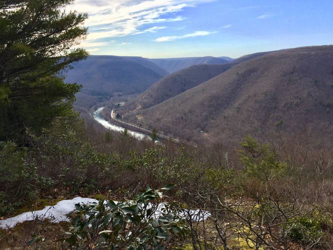
1 Trip Report


Helpful Links
Find Hiking Trails Near Me:


Before you leave...
MyHikes is an indie web platform aimed to make exploring public trails easier for everyone. The site has no investors and is owned and operated by one person, Dave Miller (Founder & Admin). As the Founder, main contributor, and doer-of-all-things for MyHikes, I share my trips with over-detailed write-ups for fun on a volunteer basis and I believe that public trail information should be available to everyone.
It takes a lot of time 🕦, money 💰, and effort (including espresso shots ☕) to run MyHikes, including hiking , mapping , writing , and publishing new trails with high-quality content... along with building new features, moderating, site maintainance, and app development for iOS and Android . I simply ask that if you find MyHikes' trail guides helpful to please consider becoming a Supporter to help keep the site, iOS, and Android apps available to everyone.
Supporters unlock website and in-app perks with a one-time payment of $25 (you renew) 😎👍. Or you can simply make a Donation of your choice without a MyHikes user account. Otherwise, telling your friends about MyHikes is the next-best thing - both quick and free 🎉
Thanks for visiting MyHikes and have a great hike!️

Dave Miller
MyHikes Founder & Admin

