Cobble Lookout Trail
Distance:
2.7 Miles / 4.3 kmType:
Out-and-BackDifficulty:
EasyTime to Hike:
1 hour, ~21 minutesFeatures:
Surface Type:
DirtLoading...
Loading...
The Cobble Lookout Trail at Adirondack Park within the Wilmington Wild Forest near Wilmington, New York is an easy 2.7-mile out-and-back trail that leads to Cobble Lookout with sweeping views of neighboring mountains like Esther Mountain, Marble Mountain, Lookout Mountain, and the Whiteface Mountain observatory if you look hard enough.
Hike Description
This hike starts along Gillespie Drive in Wilmington, NY and follows the blue blazes of the Cobble Lookout Trail heading east. The trail is mostly flat with plenty of small undulating hills along the way.
Waterfall / Ice Climbing - Mile 0.15
Around mile 0.15, hikers will find an off-shoot trail that leads to a ~34 to 40-foot cliff where a waterfall can be found. In the winter (when this trail was mapped), hikers will often find ice climbers scaling this frozen waterfall with their crampons and ice climbing axes. This can be a fun stop along the way.
After passing the quick waterfall spot, hikers will continue hiking the blue blazes east, undulating with the trail, to make their way to the Cobble Lookout.
Cobble Lookout - Mile 1.3
Finally, hikers will reach a rocky cutout along the mountain around mile 1.3 - Cobble Lookout - where the trail essentially ends. Here, hikers can take in the views of the valley below while Esther Mountain, Marble Mountain, Lookout Mountain, and the Whiteface Mountain observatory tower overhead. This view is easy to access and has a great payout for the minimal effort and time; however, it can be very windy.
Parking
Hikers will find street parking near the coordinates provided along Gillespie Road in Wilmington, New York.
Pets
Dogs are allowed if leashed and their waste should be carried out by the hiker.
Winter Hiking
During the winter, hikers should consider wearing snowshoes along this trail to keep the trail smoother for other recreational users like cross-country skiers.
-
Parking
44.403881, -73.878871 -
Main Trailhead
44.403944, -73.878882 -
View from Cobble Lookout
44.404464, -73.859069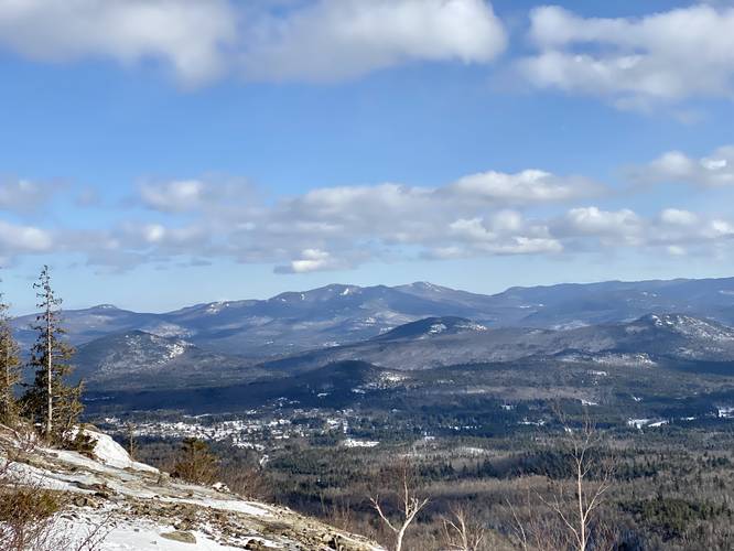
-
Esther Mountain, Lookout Mountain, and Whiteface Mountain from Cobble Lookout
44.404506, -73.859108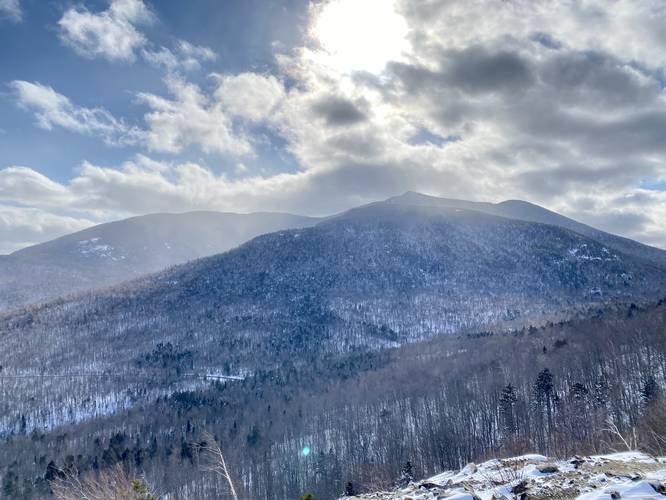
-
Ice climbers on frozen waterfall approx. 40-feet tall
44.405075, -73.876747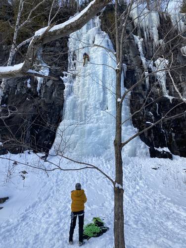
Hazards
Seasons
AllBlaze Color
2 Trip Reports


Helpful Links
Find Hiking Trails Near Me:


Before you leave...
MyHikes is an indie web platform aimed to make exploring public trails easier for everyone. The site has no investors and is owned and operated by one person, Dave Miller (Founder & Admin). As the Founder, main contributor, and doer-of-all-things for MyHikes, I share my trips with over-detailed write-ups for fun on a volunteer basis and I believe that public trail information should be available to everyone.
It takes a lot of time 🕦, money 💰, and effort (including espresso shots ☕) to run MyHikes, including hiking , mapping , writing , and publishing new trails with high-quality content... along with building new features, moderating, site maintainance, and app development for iOS and Android . I simply ask that if you find MyHikes' trail guides helpful to please consider becoming a Supporter to help keep the site, iOS, and Android apps available to everyone.
Supporters unlock website and in-app perks with a one-time payment of $25 (you renew) 😎👍. Or you can simply make a Donation of your choice without a MyHikes user account. Otherwise, telling your friends about MyHikes is the next-best thing - both quick and free 🎉
Thanks for visiting MyHikes and have a great hike!️

Dave Miller
MyHikes Founder & Admin

