Chimney Rock Vista Hike
Distance:
5.0 Miles / 8.0 kmType:
Out-and-BackDifficulty:
StrenuousTime to Hike:
2 hours, ~30 minutesFeatures:
Surface Type:
DirtLoading...
Loading...
The Chimney Rock Vista Hike at Tioga State Forest in Cedar Run, Pennsylvania is a strenuous 5-mile out-and-back hike that leads to the top of Cedar Mountain and out to a stunning view point called Chimney Rock Vista. This hike also includes several other views along with a few waterfalls and is a great day hike in the Pennsylvania Grand Canyon.
Trails
This hike follow two named trails: Bull Run Trail (yellow blazes), Chimney Rock Trail (yellow blazes).
Hike Description
This hike begins along PA Route 414 in Cedar Run and heads up the Bull Run Trail to start. This trail, despite the elevation grade shown in the chart, is much steeper than it looks. The trail immediately starts off steep, but has very few spots where the elevation grade levels out, if at all.
Bull Run Falls - Mile 0.14
Hikers will pass the largest waterfall along this hike - about 10-feet tall, around 0.14-miles into the hike. This waterfall has no name, but as the largest along Bull Run, it can be unofficially named Bull Run Falls. Just behind it, no more than 500-feet up the trail, lies another waterfall in Bull Run which spills down the mountain at about 7-feet tall total spanning across two separate tiers, Middle Bull Run Falls. Not far up the trail from the second waterfall is a third waterfall that spills down slanted rocks, but is no taller than 4-feet at best, Little Bull Run Falls. These waterfalls certainly help take the mind off of the grueling climb up the Bull Run Trail. All of the waterfalls can be enjoyed within the first 0.3-miles of the hike.
Bull Run Trail, Rocks
Around mile 0.6, with about 1/3 of the Bull Run Trail left to hike, the trail's substrate changes to large rocks which makes this uphill climb even more difficult. The elevation grade also increases along these rocks, until it levels out approximately 0.2-miles from the top of Cedar Mountain.
Chimney Rock Trail
Once hikers reach the top of Cedar Mountain, take a left-hand turn to head to the Chimney Rock Trail. Here, the trail begins to follow a pine forest with blueberry underbrush that leads along the edge of the mountain. Here, hikers will find several view points along the way located around mile 1.5 and 1.8. Hikers may also venture off-trail near mile 1.8 (heading east), to find another view point, but this requires a bushwhack.
Hike down to Chimney Rock Vista
After passing several vistas along the Chimney Rock Trail, hikers will start to head back down the mountain along a ridge. This hike becomes steeper and steeper the further down you go. Once you reach a large rock ledge, it appears as though the hike abruptly ends; however, if you look downhill and to the left, hikers will notice the rock ledge of Chimney Rock Vista below. The last section of the trail is by far the most dangerous as the mountain's elevation grade is extremely steep. Be cautious as you make your way down to the vista point.
Chimney Rock Vista - Mile 2.5
Once at Chimney Rock Vista, hikers will notice why it has this name - the rock ledge is surrounded by 50-foot drop-offs on each side - making this rock ledge stick out of the mountain side like a chimney. The view from Chimney Rock Vista is stunning as it includes several mountain peaks within and surrounding the Grand Canyon of Pennsylvania. Hikers can sit and enjoy the view, but fair warning, it's not the most fun vista if you're afraid of heights because of the massive drop-offs and extremely steep mountain grade that surround this view point.
Hiking Out
The hike out is the opposite to the hike in with the exception that the uphill climb from Chimney Rock Vista is even more difficult than any of the terrain hiking up the Bull Run Trail. Hikers will need to take their time to ensure a safe climb up and out of the vista. The hike back down the Bull Run Trail can also be tricky in several places, especially in the larger rock zones where the elevation grade is much steeper.
Parking
Hikers will find a small parking turnout next to the trailhead, on the east side of Bull Run. This parking turnout can hold about two or three cars.
Warnings
Steep elevation grade w/rocks: This trail
follows a very steep elevation grade on both trails. Hikers should bring
trekking poles and prepare for an uneven hike along sections of the
Bull Run Trail. Near Chimney Rock is the most dangerous as there are
sheer drop-offs near the rock, including near sections where the trail
connects to the rock. Hikers should be very cautious near these very
steep grades.
Rattlesnakes: Between late April and early
October, the Timber Rattlesnakes that call this area home may be out
sunning themselves on the trail or near rock ledges. Watch your step and
give them space.
Hunting: Hunting is allowed here so it's smart to wear blaze orange during hunting season.
Pets
Dogs are allowed if leashed.
Camping and Backpacking
Backpackers will find no campsites along this trail; however, there may be some spots to setup a campsite along the flatter sections of Cedar Mountain. Please follow all state forest dispersed / primitive / backcountry camping rules.
History - Bull Run Fire
Hikers may notice charred trees and other signs of forest fires along this hike. The low-growth mountain laurel, blueberry bushes, and young forests are all the result of the 2008 wildfire named the Bull Run Fire. Copied from the Tioga State Forest PDF: "In April 2008 a fire called the Bull Run Fire started on Rt. 414 south of Blackwell and raced up Bull Run Hollow. It burned for a week, traveling 2.5 miles, devastating almost 4000 forested acres. Approximately 150 fire fighters battled the blaze. Air tankers helped the fire fighters contain the massive fire that had flames at times as high as 35 feet. After the fire, large scale logging efforts took place to salvage usable wood products. Today a new forest is growing rapidly, but you can still see the charred remains of what was once there. Use caution and be aware of dead trees!"
Pine Creek Pinnacles (PCP20)
This hike is part of the Pine Creek Pinnacles hiking challenge. For more information, details, and FAQs, please visit our Pine Creek Pinnacles (PCP20) page.
-
Parking
41.534677, -77.426851 -
Main Trailhead
41.534413, -77.42693 -
10-foot waterfall along the Bull Run Trail
41.535494, -77.428589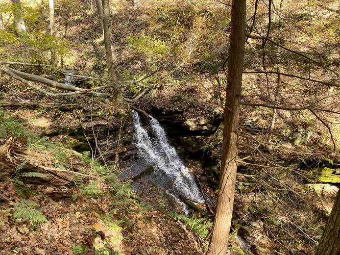
-
7-foot two-tier waterfall along the Bull Run Trail
41.535958, -77.429244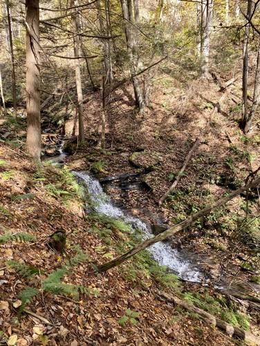
-
4-foot waterfall along the Bull Run Trail
41.536553, -77.430122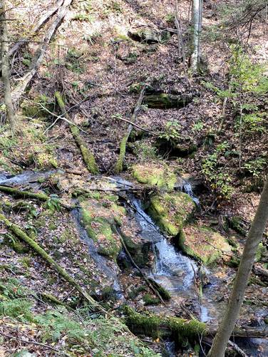
-
Chimney Rock Trail trailhead
41.542114, -77.437333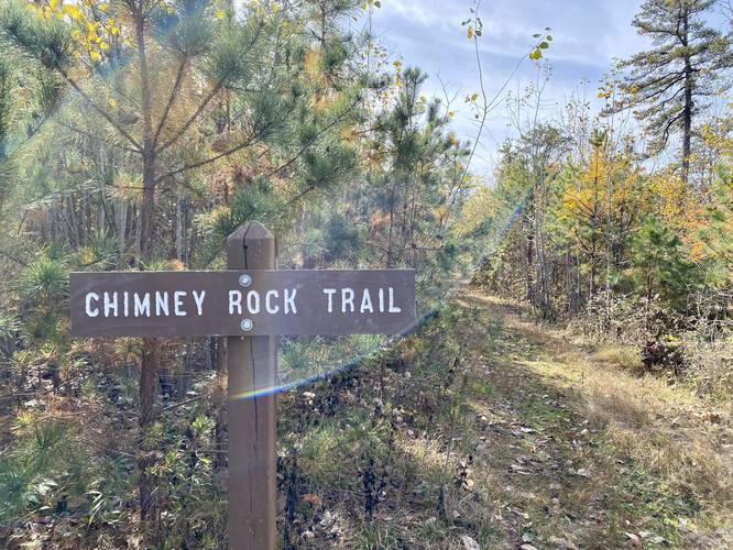
-
Chimney Rock Vista trail sign - follow the yellow blazes
41.539469, -77.439081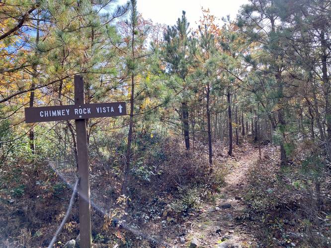
-
Vista along the Chimney Rock Trail
41.538022, -77.436936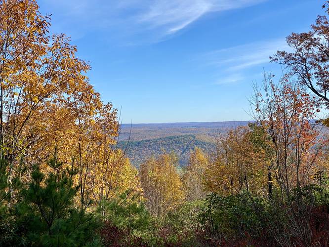
-
Vista along the Chimney Rock Trail
41.534325, -77.436303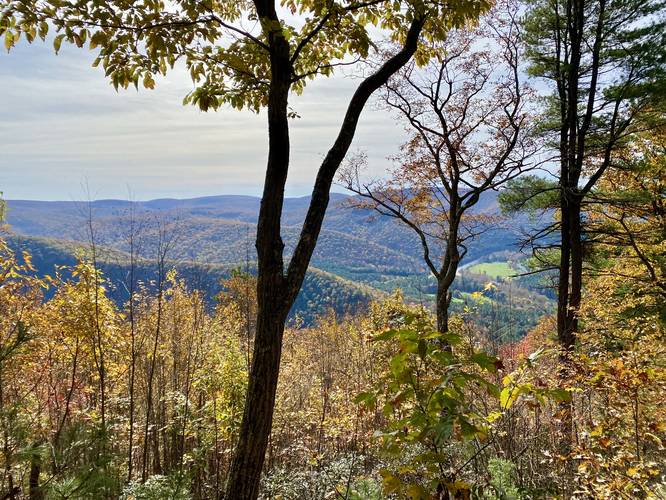
-
Chimney Rock Vista view
41.530983, -77.445342
-
Off-trail bushwhack view
41.534042, -77.434625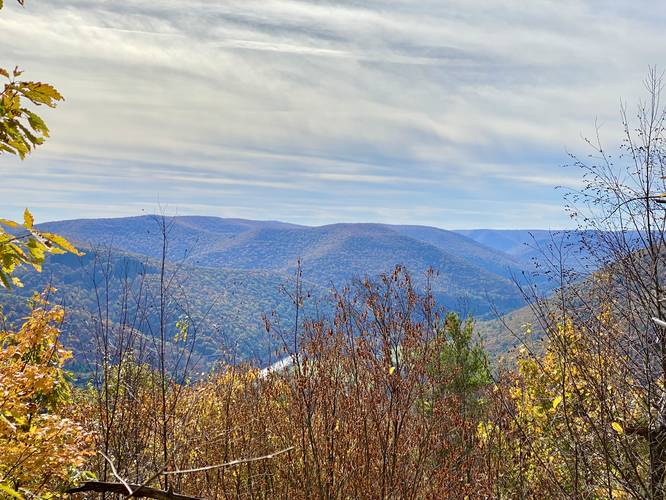
-
View Trail Map
Hiker: CoreyBHiked on: June 17, 2023Distance: 5.0 miles / 8.0 km
-
View Trail Map
Hiker: outsidezion (Nate Snavely)Hiked on: June 09, 2023Distance: 5.6 miles / 9.0 km
-
View Trail Map
Hiker: Admin (David Miller)Hiked on: October 23, 2021Distance: 4.2 miles / 6.8 km
Hazards
Seasons
Spring, Summer, FallBlaze Color


10 Trip Reports


Helpful Links
Find Hiking Trails Near Me:


Before you leave...
MyHikes is an indie web platform aimed to make exploring public trails easier for everyone. The site has no investors and is owned and operated by one person, Dave Miller (Founder & Admin). As the Founder, main contributor, and doer-of-all-things for MyHikes, I share my trips with over-detailed write-ups for fun on a volunteer basis and I believe that public trail information should be available to everyone.
It takes a lot of time 🕦, money 💰, and effort (including espresso shots ☕) to run MyHikes, including hiking , mapping , writing , and publishing new trails with high-quality content... along with building new features, moderating, site maintainance, and app development for iOS and Android . I simply ask that if you find MyHikes' trail guides helpful to please consider becoming a Supporter to help keep the site, iOS, and Android apps available to everyone.
Supporters unlock website and in-app perks with a one-time payment of $25 (you renew) 😎👍. Or you can simply make a Donation of your choice without a MyHikes user account. Otherwise, telling your friends about MyHikes is the next-best thing - both quick and free 🎉
Thanks for visiting MyHikes and have a great hike!️

Dave Miller
MyHikes Founder & Admin

