CCC-Era Stone Oven
Distance:
0.1 Miles / 0.2 kmType:
One-WayDifficulty:
EasyTime to Hike:
~5 minutesFeatures:
Surface Type:
DirtLoading...
Loading...
The CCC-Era Stone Oven in Cross Fork, Pennsylvania is one of many historically points of interest that can be found in this area in the purlieus of the Ole Bull Castle site. Near to the intersection of Joerg Road and Ole Bull Road, there is an old Stone and Brick Oven, likely used by the Ole Bull Civilian Conservation Corps (CCC) camp for meal preparation.
Trails
This structure is located just off of the Joerg Road, and can be seen from the public roadway.
Hike Description
This structure is located just off of the Joerg Road, and can be seen from the public roadway. No real hiking is required to visit this old oven.
Parking
Hikers will find a small parking turnout near by the coordinates provided. The turnout is enough for 1 vehicle but no more without blocking traffic on the Joerg Road (which could include large log trucks).
Do not block the public use of the Joerg Road, or any of the privately-leased cabin access roads, or any of the yellow-gated forest service roads in the area.
Pets
This structure is located just off of the Joerg Road, and is not dog-friendly.
Biking
Biking is allowed along all of these multi-use trails and roads in the area except for the STS. Additionally, horses are not allowed along the STS.
Camping and Backpacking
Although camping is allowed along trails in the Susquehannock State Forest, PA where state forest rules permit backcountry / dispersed / primitive camping. This structure just off of the Joerg Road, and is not suitable for Camping and Backpacking. The Susquehannock Trail System aka STS is by far the best place to camp in this area; but it would be best for the camper to park at another pre-defined parking area for any extended hikes or overnight camping trips.
Hikers can find a large parking turnout near a yellow gate along the Twelve Mile Rd. where the STS crosses the Twelve Mile Rd. See Big Trestle Trail for extended trip parking coordinates and details.
History and Historical Points of Interest
Castle Vista Trail Ole Bornemann Bull (1810 - 1880), a once-famous Norwegian violinist, relocated a colony of fellow Norwegians near the site in September 1852. From this vantage point (Nordjeuskald), Ole Bull started to build his castle, but this large wooden cabin was never completed. All that remains today is the foundation and a stone retaining wall along the mountainside. The colony disbanded and moved west after a year of severe hardships.
Dense forests of magnificent white pine, hemlock and hardwoods grew here in Potter County for many decades. In the late 1800's and early 1900's, industrial saw mills, tanneries, and chemical plants were established, using wood or bark as raw materials which brought rapid population increases. As the hillsides became barren, the population spiraled downward with much of the deforested timberland abandoned, Before than, Native Americans had passed through the forested wilderness.
Ole Bull State Park was established in 1920. The CCC camp located in the Kettle Creek watershed opened in the 1933 under the designation Ole Bull S-87-PA. Its servicemen constructed picnic shelters, dammed the creek for swimming, and assisted local foresters in fire control and reforestation of the land. The Camp Ole Bull closed in 1941. The CCC camps provided the pretrained troops to fill the ranks upon this country's mobilization into World War II in that same year, and many of the CCC servicemen readily assumed the role of Non-Commissioned Officers (NCO) in the US Army.
-
Parking
41.531519, -77.71607 -
Main Trailhead
41.531702, -77.716065 -
CCC-Era Stone Oven
41.531434, -77.716341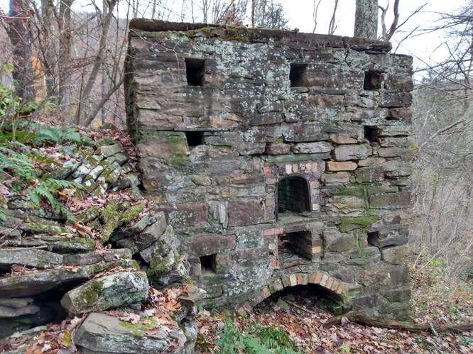
Hazards
Seasons
All
1 Trip Report


Helpful Links
Find Hiking Trails Near Me:


")


Before you leave...
MyHikes is an indie web platform aimed to make exploring public trails easier for everyone. The site has no investors and is owned and operated by one person, Dave Miller (Founder & Admin). As the Founder, main contributor, and doer-of-all-things for MyHikes, I share my trips with over-detailed write-ups for fun on a volunteer basis and I believe that public trail information should be available to everyone.
It takes a lot of time 🕦, money 💰, and effort (including espresso shots ☕) to run MyHikes, including hiking , mapping , writing , and publishing new trails with high-quality content... along with building new features, moderating, site maintainance, and app development for iOS and Android . I simply ask that if you find MyHikes' trail guides helpful to please consider becoming a Supporter to help keep the site, iOS, and Android apps available to everyone.
Supporters unlock website and in-app perks with a one-time payment of $25 (you renew) 😎👍. Or you can simply make a Donation of your choice without a MyHikes user account. Otherwise, telling your friends about MyHikes is the next-best thing - both quick and free 🎉
Thanks for visiting MyHikes and have a great hike!️

Dave Miller
MyHikes Founder & Admin

