Cavanaugh Nature Trail
Distance:
0.6 Miles / 1.0 kmType:
LoopDifficulty:
EasyTime to Hike:
~18 minutesFeatures:
Surface Type:
DirtLoading...
Loading...
The Cavanaugh Nature Trail at Tioga State Forest near Wellsboro, Pennsylvania is an easy 0.6-mile loop trail that passes through open fields in the middle of a mountainous valley. During warmer months, wildflowers can be found growing here.
The trail is a very flat which makes for an easy walk through the fields. This recording follows the outer-most loop, but there are several bisecting trails that hikers can take to cut across different portions of the outer loop.
After exploring this trail, hikers have the option to take a walk down the Pine Creek Trail since the trailhead for the Cavanaugh Nature Trail sits alongside the Pine Creek Trail.
History
This trail was built as an Eagle Scout project in 2018 by Nathan Redell's Troop 2046.
Parking
Hikers can find parking at the coordinates provided at the Cavanaugh Access Lot, which is also for the Pine Creek Trail. The parking lot is large enough to fit about a dozen vehicles.
Pets
Dogs are allowed if leashed.
-
Parking
41.777571, -77.371893 -
Main Trailhead
41.77731, -77.372135 -
Oak Point Mountain above fields of Goldenrod
41.775908, -77.372803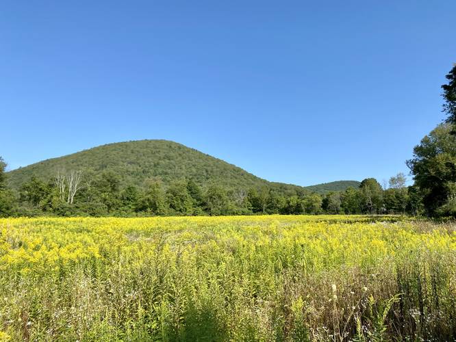
-
View Trail Map
Hiker: NeenersHiked on: August 28, 2022Distance: 0.8 miles / 1.3 km
-
View Trail Map
Hiker: Admin (David Miller)Hiked on: August 28, 2022Distance: 0.8 miles / 1.3 km
Hazards
Seasons
All


7 Trip Reports


Helpful Links
Find Hiking Trails Near Me:


Before you leave...
MyHikes is an indie web platform aimed to make exploring public trails easier for everyone. The site has no investors and is owned and operated by one person, Dave Miller (Founder & Admin). As the Founder, main contributor, and doer-of-all-things for MyHikes, I share my trips with over-detailed write-ups for fun on a volunteer basis and I believe that public trail information should be available to everyone.
It takes a lot of time 🕦, money 💰, and effort (including espresso shots ☕) to run MyHikes, including hiking , mapping , writing , and publishing new trails with high-quality content... along with building new features, moderating, site maintainance, and app development for iOS and Android . I simply ask that if you find MyHikes' trail guides helpful to please consider becoming a Supporter to help keep the site, iOS, and Android apps available to everyone.
Supporters unlock website and in-app perks with a one-time payment of $25 (you renew) 😎👍. Or you can simply make a Donation of your choice without a MyHikes user account. Otherwise, telling your friends about MyHikes is the next-best thing - both quick and free 🎉
Thanks for visiting MyHikes and have a great hike!️

Dave Miller
MyHikes Founder & Admin

