Canada Run Vista
Distance:
2.2 Miles / 3.5 kmType:
Out-and-BackDifficulty:
EasyTime to Hike:
1 hour, ~6 minutesFeatures:
Surface Type:
DirtLoading...
Loading...
The Canada Run Vista hike at Tioga State Forest near Wellsboro, Pennsylvania is an easy 2.2-mile out-and-back trail that leads to a seasonal vista at a clear-cut and includes views into Wellsboro, PA of Oak Point mountain, Round Top mountain, Mount Nessmuk, parts of Mount Tom, PA-362, and the Wellsboro Airport while perched above Canada Run creek.
Hike Description
This hike begins at the yellow service gate along Baldwin Run Rd and follows an unnamed service road south as it winds its way through a hardwood forest.
The trail slowly makes its way down the mountain and over to a steeper mountain ridge where the logger began clearing trees in March 2022. There's one left-hand turn that leads down to a more obstructed-vista clear cut, so the better view is located by staying to the right-hand side of the trail. The best vista is located around mile 1.1 (assuming you hike down to the left-hand turn first). Here, hikers get a seasonal and slightly-obstructed view facing south. From left-to-right, the view includes: the downward slope of Oak Point mountain, Round Top mountain (private land), in the background is PA-362 and the Wellsboro Airport, the top of Mount Tom, and finally Mount Nessmuk's downward slopes on the right-hand side.
Logging History (2022)
As of March 2022, when I mapped this trail, there was a solo logger
hired to cut a 100-acre clear-cut here and he started at the mountain
edge earlier that month. Since I can see this mountain from my house, I decided to
investigate. Upon both trips, I ran into the logger (see the photos of his tractor), when I learned that this logging effort was planned to be a 100-acre clear-cut and would be completed by the
end of Autumn 2022, so there will likely be more / better views in the
future.
Pets
Dogs are allowed if leashed and their waste should be carried out by the hiker.
Parking
Hikers will find parking near the service road gate. As of March 2022, there's a gas well located next to the service road gate. If you feel uncomfortable leaving your car directly next to a gas well (for various reasons), you can likely find a spot to pull off of Baldwin Run Rd as well. Please note that this road is used for trucking activities for these fracking sites - do not block the road in any way.
Camping and Backpacking
While camping is allowed here, there were no pre-defined campsites. Please follow all rules and regulations when dispersed / backcountry / primitive camping. Also note that it's likely not smart to camp in this area until after the logging has been completed, after Autumn 2022.
-
Parking
41.816659, -77.3681 -
Main Trailhead
41.816572, -77.368136 -
Obstructed view
41.80735, -77.375733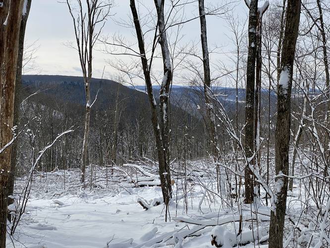
-
Canada Run Vista (obstructed / seasonal)
41.8068, -77.376647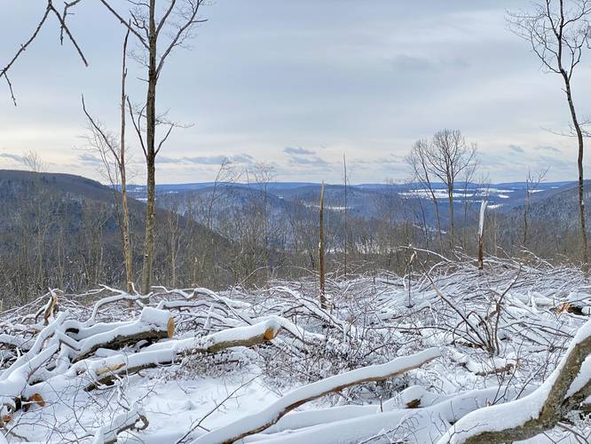
-
Canada Run Vista (obstructed / seasonal)
41.806197, -77.376983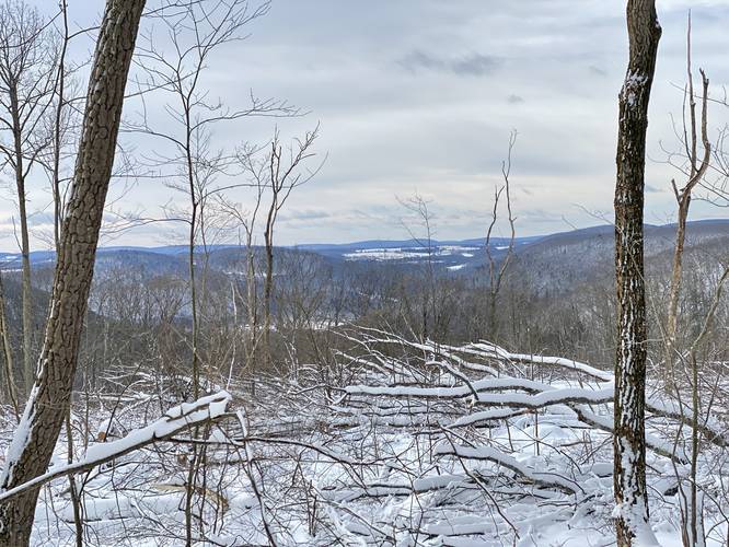
Hazards
Seasons
All
3 Trip Reports


Helpful Links
Find Hiking Trails Near Me:


")


Before you leave...
MyHikes is an indie web platform aimed to make exploring public trails easier for everyone. The site has no investors and is owned and operated by one person, Dave Miller (Founder & Admin). As the Founder, main contributor, and doer-of-all-things for MyHikes, I share my trips with over-detailed write-ups for fun on a volunteer basis and I believe that public trail information should be available to everyone.
It takes a lot of time 🕦, money 💰, and effort (including espresso shots ☕) to run MyHikes, including hiking , mapping , writing , and publishing new trails with high-quality content... along with building new features, moderating, site maintainance, and app development for iOS and Android . I simply ask that if you find MyHikes' trail guides helpful to please consider becoming a Supporter to help keep the site, iOS, and Android apps available to everyone.
Supporters unlock website and in-app perks with a one-time payment of $25 (you renew) 😎👍. Or you can simply make a Donation of your choice without a MyHikes user account. Otherwise, telling your friends about MyHikes is the next-best thing - both quick and free 🎉
Thanks for visiting MyHikes and have a great hike!️

Dave Miller
MyHikes Founder & Admin

