Cadot Trail to Skatutakee Summit
Distance:
3.0 Miles / 4.8 kmType:
Out-and-BackDifficulty:
ModerateTime to Hike:
1 hour, ~30 minutesFeatures:
Surface Type:
Dirt
The Cadot Trail at the Harris Center for Conservation Education / Harris Center Conservation Area in Hancock, New Hampshire is a moderate 3-mile out-and-back trail that leads to the summit of Skatutakee Mountain and features beautiful views.
Trail Name: Cadot Trail
Location: Old Dublin Road, Hancock NH
Allowed activities: walking, hiking, snowshoeing, birding, geocaching, foraging
Forbidden activities: No fires, no hunting, no camping, no smoking
Hours: Trails are open daily even when the Harris Center building is closed
Parking and fees: There is limited of parking at the trailhead. Do not block the wooden gate. There is no fee to use the parking or the trail.
Pets: Dogs are allowed on the trail as long as they are leashed and waste is carried out with the hiker.
Accessibility: Hikers will encounter very rocky and uneven terrain on this hike with multiple trip hazards.
Sanitation: No Restrooms or trash bins are available to visitors. Please carry out all trash or animal waste.
Trail information: There is a Trail kiosk with a posted map and trail information at the trail head parking area. To download a printable map to take with you before your hike, please follow the link below:
https://harriscenter.org/wp-content/uploads/2018/10/WestSideTrails_Map_Oct2018.pdf
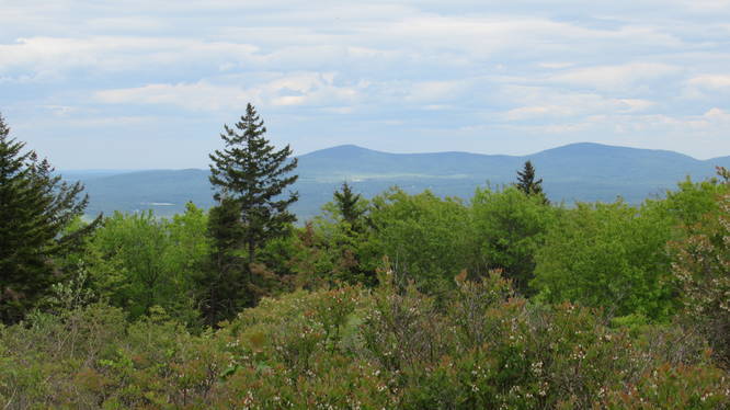
Length and features: The Cadot Trail is part of the Harris Center Conservation Area and can be located on the maps for the west side trails. The trail is a moderate 2.97 mile “out and back” hike that leads hikers up to the Skatutakee Mountain summit. The trail blaze markers for the Cadot trail are white markers. There are no trail markers on the beginning section of the trail that runs from east to west, but they are not really necessary. The trail here looks very much like an old class 6 road: it is very wide and evident. The trail begins to ascend almost immediately, however it is not a steep incline. The ascent is slow and steady as you work your way along the gravely trail. The Cadot Trail appears to have fewer visitors than the other trails that originate from the Harris Center. There might be less maintenance on this trail as evidenced in the large trees and debris found across sections of the trail. The downed trees are not difficult to go over or around. Hikers won’t notice trail blaze markers until they reach the part of the trail where it veers off to the north and heads up the side of the mountain. Once the trail starts to incline steeply, there are plenty of markers to assist the hiker in staying on the trail. The view from the summit is worth the effort and the trail through the mixed forest is beautiful. There are several very old very large trees in this part of the Harris Center Conservation area. Hikers will also find varied flora and be able to hear all kinds of birdsong during their visit. The summit has beautiful views of the surrounding area, and if you plan your trip during blueberry season you will get to indulge in plenty of trailside foraging. There is even a geocache not too far from the summit to hunt for.
Explore 79 trails near Hancock, NHHazards
Seasons
AllBlaze Color
Blaze Dot
Loading...
Loading...
1 Trip Report


Helpful Links
Find Hiking Trails Near Me:


Before you leave...
MyHikes is an indie web platform aimed to make exploring public trails easier for everyone. The site has no investors and is owned and operated by one person, Dave Miller (Founder & Admin). As the Founder, main contributor, and doer-of-all-things for MyHikes, I share my trips with over-detailed write-ups for fun on a volunteer basis and I believe that public trail information should be available to everyone.
It takes a lot of time 🕦, money 💰, and effort (including espresso shots ☕) to run MyHikes, including hiking , mapping , writing , and publishing new trails with high-quality content... along with building new features, moderating, site maintainance, and app development for iOS and Android . I simply ask that if you find MyHikes' trail guides helpful to please consider becoming a Supporter to help keep the site, iOS, and Android apps available to everyone.
Supporters unlock website and in-app perks with a one-time payment of $25 (you renew) 😎👍. Or you can simply make a Donation of your choice without a MyHikes user account. Otherwise, telling your friends about MyHikes is the next-best thing - both quick and free 🎉
Thanks for visiting MyHikes and have a great hike!️

Dave Miller
MyHikes Founder & Admin

