Belly of the Dragon Trail
Distance:
0.3 Miles / 0.5 kmType:
Out-and-BackDifficulty:
EasyTime to Hike:
~15 minutesFeatures:
Surface Type:
DirtLoading...
Loading...
The Belly of the Dragon Trail near Mount Carmel Junction, Utah is an easy 0.3-mile out-and-back hike that features a large rock tunnel that passes under US-89 known as the Belly of the Dragon.
This very short hike begins on the west side of US-89 on a road named Elephant Gap Road (on Google maps). Hikers will take the main trail located on the northern side of the parking lot as it skirts along the cliffs edge. The trail essentially "ends" at the entrance for the Belly of the Dragon; however, there's a ~7-foot rock scramble that hikers can take to reach the actual entrance of the tunnel. After scrambling down, you'll be at the "mouth" of the Belly of the Dragon - hike in to explore it further. Hikers will notice a plethora of hand-carved names (graffiti), initials, and symbols on the walls of the Belly of the Dragon. These carvings extend pretty-far into the tunnel. As you head in deeper into the Belly of the Dragon, it's smart to turn on your phone's flashlight to be able to see the windy rock path that leads through - including fallen rock that might be a tripping hazard. Finally, hikers will pop out on the other side of the tunnel -- where this track ends -- before heading back to parking.
Parking
Hikers will find parking at the coordinates provided, along Elephant Gap Road - just off of US-89 in Orderville, Utah.
Pets
Dogs are allowed if leashed and cleaned up after -- but note the 7-foot rock scramble to enter the Belly of the Dragon, which not all dogs can do.
Waterfalls
Note that this information might be wrong, however, due to the likeliness that this tunnel is used to move water under the highway from one side to another, the large ~10-foot tall concrete structure located at the entrance to the tunnel would definitely be a waterfall feature during periods of heavy rainfall; however, if that's the case, the tunnel itself is clearly not viable for human entry. If this tunnel is used for water passage, then there would be a seasonal or temporary 10-foot waterfall at the entrance to the tunnel.
Warnings
Rattlesnakes: This area is home to rattlesnakes which might be out sunning in the midday sun. Be on the lookout and keep your distance if you find any rattlers.
Rockfall / falling rock: This hike passes through a rock tunnel that occasionally has rockfall / falling rock activity. Hike at your own risk.
Flash flooding: It appears as though the Belly of the Dragon may actually be a dry wash -- evidence of the smooth-carved rock in the tunnel -- in addition to the concrete human-made "waterfall" at the entrance indicate that this tunnel is used to move water under the highway. If that's the case, hikers should be aware of the local weather upstream to ensure that they stay out of the tunnel during periods of heavy rain.
-
Parking
37.211626, -112.685177 -
Main Trailhead
37.211497, -112.685098 -
Scramble down into the Belly of the Dragon
37.21113, -112.684846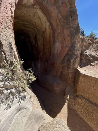
Hazards
Seasons
All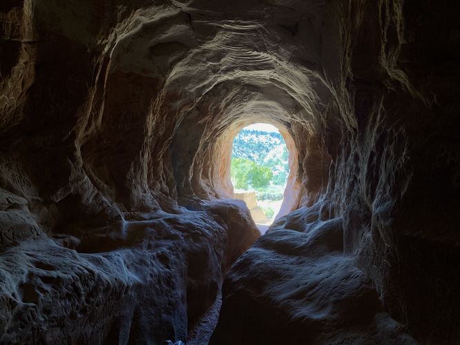
2 Trip Reports


Helpful Links
Find Hiking Trails Near Me:


Before you leave...
MyHikes is an indie web platform aimed to make exploring public trails easier for everyone. The site has no investors and is owned and operated by one person, Dave Miller (Founder & Admin). As the Founder, main contributor, and doer-of-all-things for MyHikes, I share my trips with over-detailed write-ups for fun on a volunteer basis and I believe that public trail information should be available to everyone.
It takes a lot of time 🕦, money 💰, and effort (including espresso shots ☕) to run MyHikes, including hiking , mapping , writing , and publishing new trails with high-quality content... along with building new features, moderating, site maintainance, and app development for iOS and Android . I simply ask that if you find MyHikes' trail guides helpful to please consider becoming a Supporter to help keep the site, iOS, and Android apps available to everyone.
Supporters unlock website and in-app perks with a one-time payment of $25 (you renew) 😎👍. Or you can simply make a Donation of your choice without a MyHikes user account. Otherwise, telling your friends about MyHikes is the next-best thing - both quick and free 🎉
Thanks for visiting MyHikes and have a great hike!️

Dave Miller
MyHikes Founder & Admin

