Ashley Reservoir Loop
Distance:
3.5 Miles / 5.6 kmType:
LoopDifficulty:
EasyTime to Hike:
1 hour, ~45 minutesFeatures:
Surface Type:
DirtLoading...
Loading...
The Ashley Reservoir Loop is an easy 3.5 mile trail located in Holyoke, Massachusetts off of Rt-202. The reservoir offers views and a wide mostly-flat gravel path. This is a very popular location but the trail is long enough to provide some level of privacy. The shallow banks of Ashley Pond also offer great views of fish; however, fishing is not allowed.
Parking
There's a modest parking lot along Westfield Rd and street parking is available during peak season at the coordinates provided.
Pets
Dogs are not allowed at Ashley Reservoir. Note that a hiker left a trip report in early 2021 after being fined for having their dog on-leash at Ashley Reservoir along the Wright Pond Inner Loop. Because of this, we suggest leaving your furry friends at home for this reservoir loop hike as well.
Hazards
Seasons
All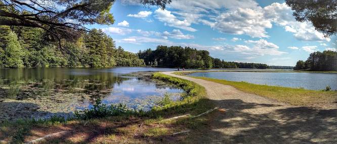

3 Trip Reports


Helpful Links
Find Hiking Trails Near Me:


Before you leave...
MyHikes is an indie web platform aimed to make exploring public trails easier for everyone. The site has no investors and is owned and operated by one person, Dave Miller (Founder & Admin). As the Founder, main contributor, and doer-of-all-things for MyHikes, I share my trips with over-detailed write-ups for fun on a volunteer basis and I believe that public trail information should be available to everyone.
It takes a lot of time 🕦, money 💰, and effort (including espresso shots ☕) to run MyHikes, including hiking , mapping , writing , and publishing new trails with high-quality content... along with building new features, moderating, site maintainance, and app development for iOS and Android . I simply ask that if you find MyHikes' trail guides helpful to please consider becoming a Supporter to help keep the site, iOS, and Android apps available to everyone.
Supporters unlock website and in-app perks with a one-time payment of $25 (you renew) 😎👍. Or you can simply make a Donation of your choice without a MyHikes user account. Otherwise, telling your friends about MyHikes is the next-best thing - both quick and free 🎉
Thanks for visiting MyHikes and have a great hike!️

Dave Miller
MyHikes Founder & Admin

