Allegheny River Trail - Mile 23 to 24
Distance:
1.8 Miles / 2.9 kmType:
Out-and-BackDifficulty:
EasyTime to Hike:
~54 minutesFeatures:
Surface Type:
PavedLoading...
Loading...
This short section of the Allegheny River Trail in Kennerdell, Pennsylvania is an easy 1.8-mile out-and-back hike from mile 23 to 24 and back to parking. This is a flat and paved trail that runs the length of the Allegheny River and is part of the Erie to Pittsburgh Trail.
We stumbled on this trail after trying to reach Freedom Falls, which is currently inaccessible to drive to due to the closed bridge on the road. The closed bridge to Freedom Falls, along T522, is just a stones-throw away from the parking lot here.
Follow the trail from the parking lot and head up the small hill to the paved trail and follow the trail north along the river, with the river to your left-hand side.
The trail goes on for dozens of miles, hence why we only walked a couple here; however, it does not link up with Freedom Falls unfortunately. If you plan to reach Freedom Falls from the parking lot here, it's a 10-mile bushwhack - up and down massive and steep hills to get there. This parking lot is likely the closest place you can park to reach Freedom Falls, which is a shame.
Waterfalls: During the rainy seasons you can find waterfalls cascading down the hillsides along the cliffs next to the trail. Some of the waterfalls are a bit tough to see since they sit far back from the trail, but are really nice nonetheless.
Dogs and biking are both allowed on this trail.
Hazards
Seasons
All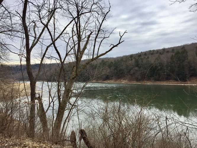
2 Trip Reports


Helpful Links
Find Hiking Trails Near Me:


Before you leave...
MyHikes is an indie web platform aimed to make exploring public trails easier for everyone. The site has no investors and is owned and operated by one person, Dave Miller (Founder & Admin). As the Founder, main contributor, and doer-of-all-things for MyHikes, I share my trips with over-detailed write-ups for fun on a volunteer basis and I believe that public trail information should be available to everyone.
It takes a lot of time 🕦, money 💰, and effort (including espresso shots ☕) to run MyHikes, including hiking , mapping , writing , and publishing new trails with high-quality content... along with building new features, moderating, site maintainance, and app development for iOS and Android . I simply ask that if you find MyHikes' trail guides helpful to please consider becoming a Supporter to help keep the site, iOS, and Android apps available to everyone.
Supporters unlock website and in-app perks with a one-time payment of $25 (you renew) 😎👍. Or you can simply make a Donation of your choice without a MyHikes user account. Otherwise, telling your friends about MyHikes is the next-best thing - both quick and free 🎉
Thanks for visiting MyHikes and have a great hike!️

Dave Miller
MyHikes Founder & Admin

